You are here: Home > Network List > TA - USArray Transportable Network (new EarthScope stations) Stations List
> Station F21K Alatna River, AK, USA > Earthquake Result Viewer
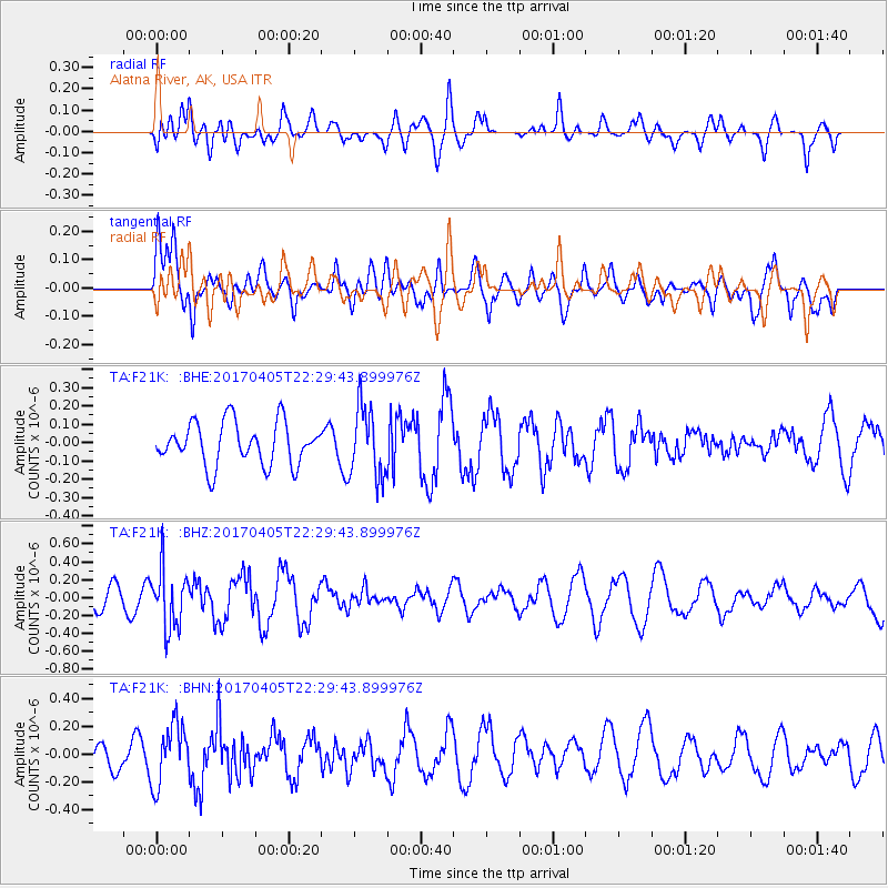
F21K Alatna River, AK, USA - Earthquake Result Viewer
*The percent match for this event was below the threshold and hence no stack was calculated.
| Earthquake location: |
Vanuatu Islands |
| Earthquake latitude/longitude: |
-19.0/169.6 |
| Earthquake time(UTC): |
2017/04/05 (095) 22:17:42 GMT |
| Earthquake Depth: |
248 km |
| Earthquake Magnitude: |
5.6 Mww |
| Earthquake Catalog/Contributor: |
NEIC PDE/us |
|
| Network: |
TA USArray Transportable Network (new EarthScope stations) |
| Station: |
F21K Alatna River, AK, USA |
| Lat/Lon: |
67.22 N/153.48 W |
| Elevation: |
597 m |
|
| Distance: |
90.2 deg |
| Az: |
13.533 deg |
| Baz: |
214.658 deg |
| Ray Param: |
$rayparam |
*The percent match for this event was below the threshold and hence was not used in the summary stack. |
|
| Radial Match: |
52.328835 % |
| Radial Bump: |
400 |
| Transverse Match: |
74.419304 % |
| Transverse Bump: |
400 |
| SOD ConfigId: |
11737051 |
| Insert Time: |
2019-04-27 01:33:14.729 +0000 |
| GWidth: |
2.5 |
| Max Bumps: |
400 |
| Tol: |
0.001 |
|
Signal To Noise
| Channel | StoN | STA | LTA |
| TA:F21K: :BHZ:20170405T22:29:43.899976Z | 2.2831457 | 3.255889E-7 | 1.4260539E-7 |
| TA:F21K: :BHN:20170405T22:29:43.899976Z | 2.5008445 | 2.1794416E-7 | 8.714823E-8 |
| TA:F21K: :BHE:20170405T22:29:43.899976Z | 1.6586596 | 1.9330044E-7 | 1.1654016E-7 |
| Arrivals |
| Ps | |
| PpPs | |
| PsPs/PpSs | |


