You are here: Home > Network List > TA - USArray Transportable Network (new EarthScope stations) Stations List
> Station R22A Saguache, Gunnison, CO, USA > Earthquake Result Viewer
R22A Saguache, Gunnison, CO, USA - Earthquake Result Viewer
| Earthquake location: |
Kuril Islands |
| Earthquake latitude/longitude: |
51.0/157.6 |
| Earthquake time(UTC): |
2008/07/24 (206) 01:43:16 GMT |
| Earthquake Depth: |
27 km |
| Earthquake Magnitude: |
6.0 MB, 6.0 MS, 6.2 MW, 6.2 MW |
| Earthquake Catalog/Contributor: |
WHDF/NEIC |
|
| Network: |
TA USArray Transportable Network (new EarthScope stations) |
| Station: |
R22A Saguache, Gunnison, CO, USA |
| Lat/Lon: |
38.23 N/106.76 W |
| Elevation: |
2773 m |
|
| Distance: |
64.6 deg |
| Az: |
60.145 deg |
| Baz: |
315.866 deg |
| Ray Param: |
0.058754377 |
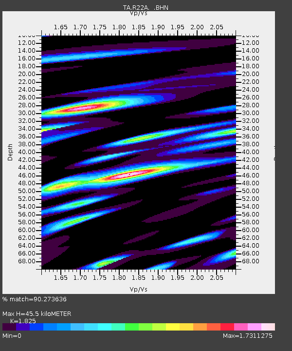
| Estimated Moho Depth: |
45.5 km |
| Estimated Crust Vp/Vs: |
1.83 |
| Assumed Crust Vp: |
6.306 km/s |
| Estimated Crust Vs: |
3.455 km/s |
| Estimated Crust Poisson's Ratio: |
0.29 |
|
| Radial Match: |
90.273636 % |
| Radial Bump: |
400 |
| Transverse Match: |
88.855385 % |
| Transverse Bump: |
400 |
| SOD ConfigId: |
2504 |
| Insert Time: |
2010-03-05 22:51:16.962 +0000 |
| GWidth: |
2.5 |
| Max Bumps: |
400 |
| Tol: |
0.001 |
|

Signal To Noise
| Channel | StoN | STA | LTA |
| TA:R22A: :BHN:20080724T01:53:20.350022Z | 14.317784 | 1.7302976E-6 | 1.2084953E-7 |
| TA:R22A: :BHE:20080724T01:53:20.350022Z | 5.656452 | 7.249382E-7 | 1.2816129E-7 |
| TA:R22A: :BHZ:20080724T01:53:20.350022Z | 5.131279 | 6.4015677E-7 | 1.2475579E-7 |
| Arrivals |
| Ps | 6.2 SECOND |
| PpPs | 20 SECOND |
| PsPs/PpSs | 26 SECOND |


