You are here: Home > Network List > UW - Pacific Northwest Regional Seismic Network Stations List
> Station LEBA Lebam, WA, USA > Earthquake Result Viewer
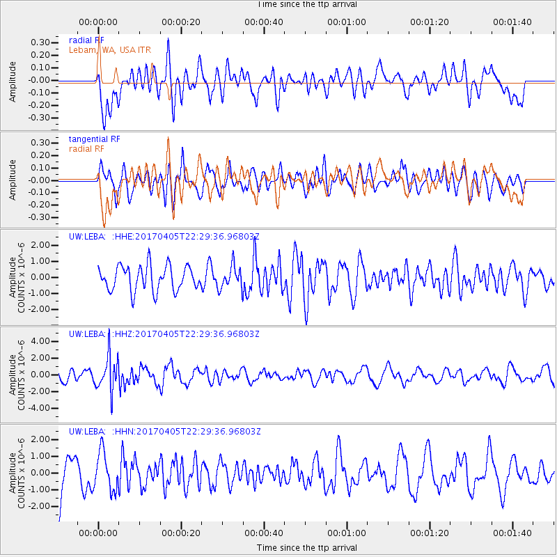
LEBA Lebam, WA, USA - Earthquake Result Viewer
*The percent match for this event was below the threshold and hence no stack was calculated.
| Earthquake location: |
Vanuatu Islands |
| Earthquake latitude/longitude: |
-19.0/169.6 |
| Earthquake time(UTC): |
2017/04/05 (095) 22:17:42 GMT |
| Earthquake Depth: |
248 km |
| Earthquake Magnitude: |
5.6 Mww |
| Earthquake Catalog/Contributor: |
NEIC PDE/us |
|
| Network: |
UW Pacific Northwest Regional Seismic Network |
| Station: |
LEBA Lebam, WA, USA |
| Lat/Lon: |
46.55 N/123.56 W |
| Elevation: |
73 m |
|
| Distance: |
88.7 deg |
| Az: |
39.408 deg |
| Baz: |
240.498 deg |
| Ray Param: |
$rayparam |
*The percent match for this event was below the threshold and hence was not used in the summary stack. |
|
| Radial Match: |
50.96963 % |
| Radial Bump: |
400 |
| Transverse Match: |
50.29198 % |
| Transverse Bump: |
400 |
| SOD ConfigId: |
11737051 |
| Insert Time: |
2019-04-27 01:34:20.520 +0000 |
| GWidth: |
2.5 |
| Max Bumps: |
400 |
| Tol: |
0.001 |
|
Signal To Noise
| Channel | StoN | STA | LTA |
| UW:LEBA: :HHZ:20170405T22:29:36.96803Z | 3.1340005 | 2.0617072E-6 | 6.5785156E-7 |
| UW:LEBA: :HHN:20170405T22:29:36.96803Z | 1.3856342 | 1.1579426E-6 | 8.35677E-7 |
| UW:LEBA: :HHE:20170405T22:29:36.96803Z | 0.89002305 | 6.88535E-7 | 7.736148E-7 |
| Arrivals |
| Ps | |
| PpPs | |
| PsPs/PpSs | |


