You are here: Home > Network List > UW - Pacific Northwest Regional Seismic Network Stations List
> Station YACT Amboy, WA, USA > Earthquake Result Viewer
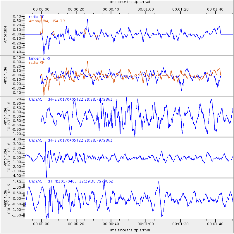
YACT Amboy, WA, USA - Earthquake Result Viewer
*The percent match for this event was below the threshold and hence no stack was calculated.
| Earthquake location: |
Vanuatu Islands |
| Earthquake latitude/longitude: |
-19.0/169.6 |
| Earthquake time(UTC): |
2017/04/05 (095) 22:17:42 GMT |
| Earthquake Depth: |
248 km |
| Earthquake Magnitude: |
5.6 Mww |
| Earthquake Catalog/Contributor: |
NEIC PDE/us |
|
| Network: |
UW Pacific Northwest Regional Seismic Network |
| Station: |
YACT Amboy, WA, USA |
| Lat/Lon: |
45.93 N/122.42 W |
| Elevation: |
211 m |
|
| Distance: |
89.1 deg |
| Az: |
40.33 deg |
| Baz: |
241.339 deg |
| Ray Param: |
$rayparam |
*The percent match for this event was below the threshold and hence was not used in the summary stack. |
|
| Radial Match: |
47.404926 % |
| Radial Bump: |
400 |
| Transverse Match: |
53.016754 % |
| Transverse Bump: |
400 |
| SOD ConfigId: |
11737051 |
| Insert Time: |
2019-04-27 01:34:27.422 +0000 |
| GWidth: |
2.5 |
| Max Bumps: |
400 |
| Tol: |
0.001 |
|
Signal To Noise
| Channel | StoN | STA | LTA |
| UW:YACT: :HHZ:20170405T22:29:38.797986Z | 3.549465 | 1.5816125E-6 | 4.4559184E-7 |
| UW:YACT: :HHN:20170405T22:29:38.797986Z | 1.4884354 | 9.975746E-7 | 6.7021693E-7 |
| UW:YACT: :HHE:20170405T22:29:38.797986Z | 1.000632 | 4.6484735E-7 | 4.6455372E-7 |
| Arrivals |
| Ps | |
| PpPs | |
| PsPs/PpSs | |


