You are here: Home > Network List > CI - Caltech Regional Seismic Network Stations List
> Station DAN Danby, California, USA > Earthquake Result Viewer
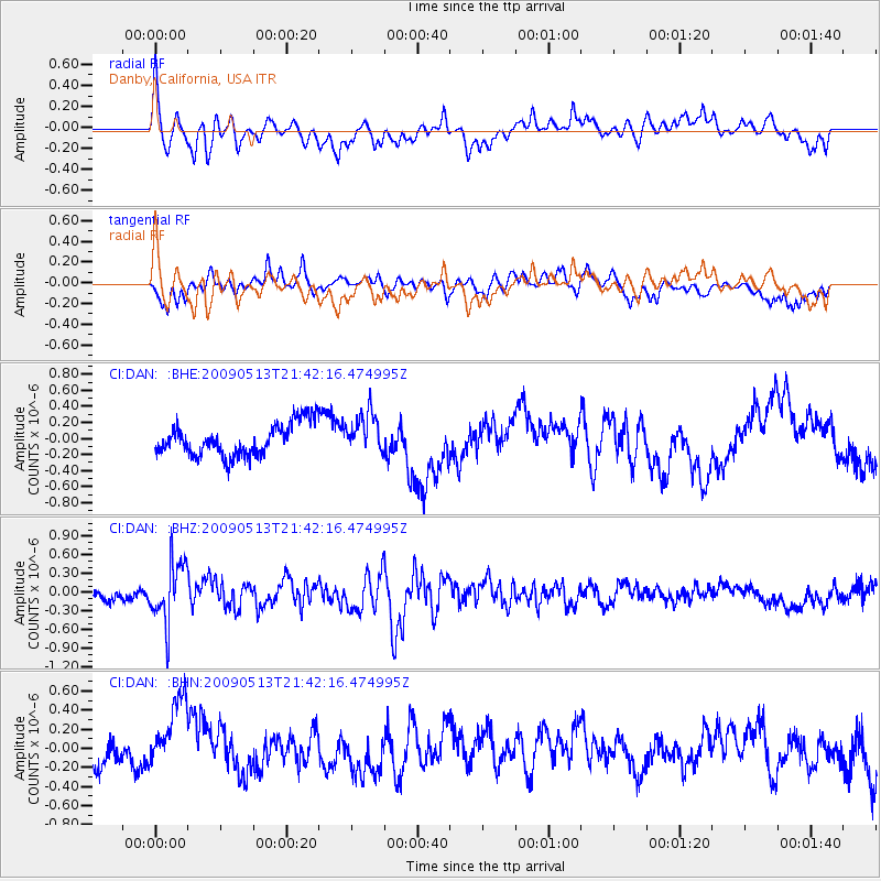
DAN Danby, California, USA - Earthquake Result Viewer
*The percent match for this event was below the threshold and hence no stack was calculated.
| Earthquake location: |
Tonga Islands |
| Earthquake latitude/longitude: |
-15.8/-173.5 |
| Earthquake time(UTC): |
2009/05/13 (133) 21:31:17 GMT |
| Earthquake Depth: |
85 km |
| Earthquake Magnitude: |
5.8 MW, 5.3 MB, 5.8 MW |
| Earthquake Catalog/Contributor: |
WHDF/NEIC |
|
| Network: |
CI Caltech Regional Seismic Network |
| Station: |
DAN Danby, California, USA |
| Lat/Lon: |
34.64 N/115.38 W |
| Elevation: |
398 m |
|
| Distance: |
74.5 deg |
| Az: |
46.588 deg |
| Baz: |
238.032 deg |
| Ray Param: |
$rayparam |
*The percent match for this event was below the threshold and hence was not used in the summary stack. |
|
| Radial Match: |
54.455547 % |
| Radial Bump: |
372 |
| Transverse Match: |
58.140507 % |
| Transverse Bump: |
369 |
| SOD ConfigId: |
2760 |
| Insert Time: |
2010-02-26 01:06:07.659 +0000 |
| GWidth: |
2.5 |
| Max Bumps: |
400 |
| Tol: |
0.001 |
|
Signal To Noise
| Channel | StoN | STA | LTA |
| CI:DAN: :BHZ:20090513T21:42:16.474995Z | 4.4206276 | 4.8623497E-7 | 1.0999229E-7 |
| CI:DAN: :BHN:20090513T21:42:16.474995Z | 2.5431232 | 4.1567878E-7 | 1.6345209E-7 |
| CI:DAN: :BHE:20090513T21:42:16.474995Z | 1.2569385 | 2.5178727E-7 | 2.003179E-7 |
| Arrivals |
| Ps | |
| PpPs | |
| PsPs/PpSs | |


