You are here: Home > Network List > CI - Caltech Regional Seismic Network Stations List
> Station DAN Danby, California, USA > Earthquake Result Viewer
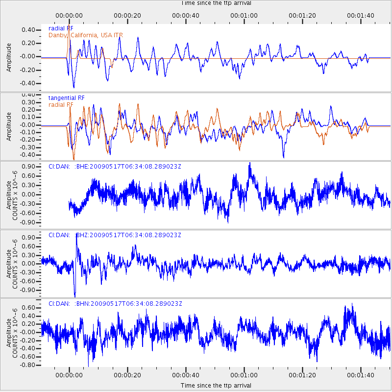
DAN Danby, California, USA - Earthquake Result Viewer
*The percent match for this event was below the threshold and hence no stack was calculated.
| Earthquake location: |
Tonga Islands |
| Earthquake latitude/longitude: |
-16.8/-173.5 |
| Earthquake time(UTC): |
2009/05/17 (137) 06:23:03 GMT |
| Earthquake Depth: |
67 km |
| Earthquake Magnitude: |
5.5 MB, 5.6 MW, 5.6 MW |
| Earthquake Catalog/Contributor: |
WHDF/NEIC |
|
| Network: |
CI Caltech Regional Seismic Network |
| Station: |
DAN Danby, California, USA |
| Lat/Lon: |
34.64 N/115.38 W |
| Elevation: |
398 m |
|
| Distance: |
75.3 deg |
| Az: |
46.379 deg |
| Baz: |
237.23 deg |
| Ray Param: |
$rayparam |
*The percent match for this event was below the threshold and hence was not used in the summary stack. |
|
| Radial Match: |
59.93419 % |
| Radial Bump: |
400 |
| Transverse Match: |
60.270603 % |
| Transverse Bump: |
400 |
| SOD ConfigId: |
2760 |
| Insert Time: |
2010-02-26 01:06:08.249 +0000 |
| GWidth: |
2.5 |
| Max Bumps: |
400 |
| Tol: |
0.001 |
|
Signal To Noise
| Channel | StoN | STA | LTA |
| CI:DAN: :BHZ:20090517T06:34:08.289023Z | 2.8527887 | 4.2967457E-7 | 1.5061563E-7 |
| CI:DAN: :BHN:20090517T06:34:08.289023Z | 1.1147758 | 1.9913351E-7 | 1.7863101E-7 |
| CI:DAN: :BHE:20090517T06:34:08.289023Z | 0.8783934 | 2.3285148E-7 | 2.6508792E-7 |
| Arrivals |
| Ps | |
| PpPs | |
| PsPs/PpSs | |


