You are here: Home > Network List > TA - USArray Transportable Network (new EarthScope stations) Stations List
> Station F21K Alatna River, AK, USA > Earthquake Result Viewer
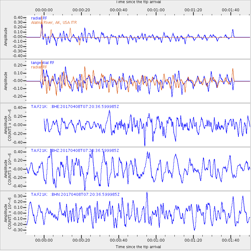
F21K Alatna River, AK, USA - Earthquake Result Viewer
*The percent match for this event was below the threshold and hence no stack was calculated.
| Earthquake location: |
Mindoro, Philippines |
| Earthquake latitude/longitude: |
13.7/120.9 |
| Earthquake time(UTC): |
2017/04/08 (098) 07:09:27 GMT |
| Earthquake Depth: |
43 km |
| Earthquake Magnitude: |
5.9 Mww |
| Earthquake Catalog/Contributor: |
NEIC PDE/us |
|
| Network: |
TA USArray Transportable Network (new EarthScope stations) |
| Station: |
F21K Alatna River, AK, USA |
| Lat/Lon: |
67.22 N/153.48 W |
| Elevation: |
597 m |
|
| Distance: |
75.7 deg |
| Az: |
23.613 deg |
| Baz: |
271.356 deg |
| Ray Param: |
$rayparam |
*The percent match for this event was below the threshold and hence was not used in the summary stack. |
|
| Radial Match: |
60.84227 % |
| Radial Bump: |
400 |
| Transverse Match: |
61.879593 % |
| Transverse Bump: |
400 |
| SOD ConfigId: |
11737051 |
| Insert Time: |
2019-04-27 01:44:24.573 +0000 |
| GWidth: |
2.5 |
| Max Bumps: |
400 |
| Tol: |
0.001 |
|
Signal To Noise
| Channel | StoN | STA | LTA |
| TA:F21K: :BHZ:20170408T07:20:36.599985Z | 2.1716082 | 2.649538E-7 | 1.220081E-7 |
| TA:F21K: :BHN:20170408T07:20:36.599985Z | 0.6639948 | 7.504314E-8 | 1.1301766E-7 |
| TA:F21K: :BHE:20170408T07:20:36.599985Z | 1.864509 | 1.5892249E-7 | 8.523557E-8 |
| Arrivals |
| Ps | |
| PpPs | |
| PsPs/PpSs | |


