You are here: Home > Network List > AV - Alaska Volcano Observatory Stations List
> Station SPCR Ckakachatna River, Mount Spurr, Alaska > Earthquake Result Viewer
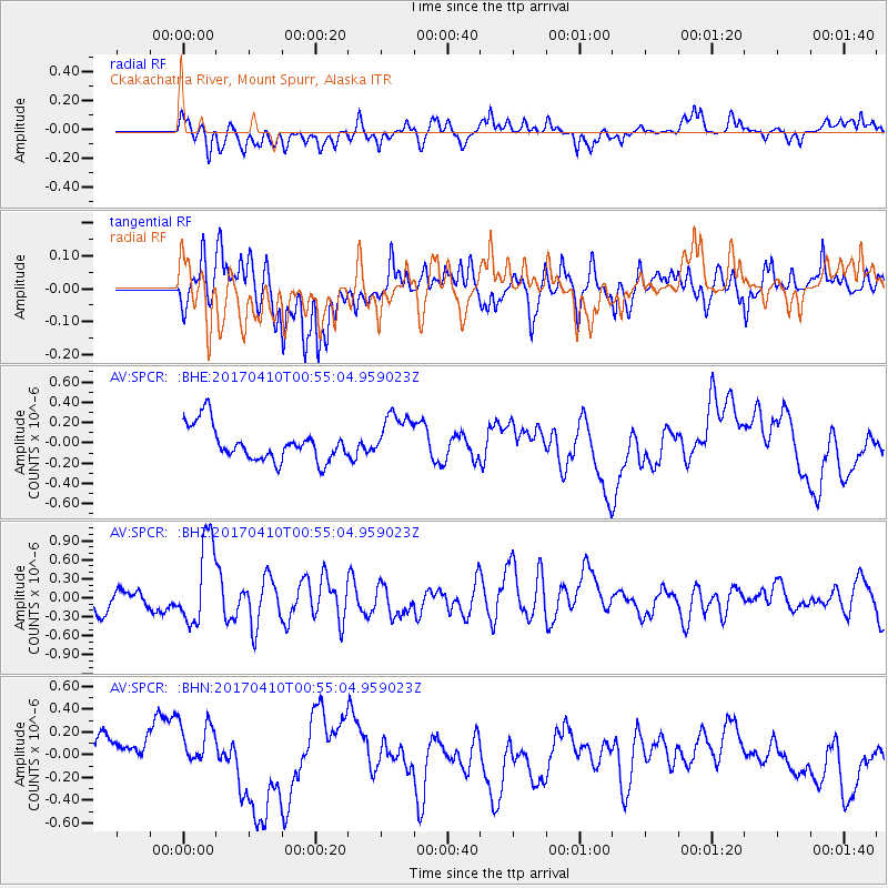
SPCR Ckakachatna River, Mount Spurr, Alaska - Earthquake Result Viewer
*The percent match for this event was below the threshold and hence no stack was calculated.
| Earthquake location: |
Philippine Islands Region |
| Earthquake latitude/longitude: |
13.0/125.4 |
| Earthquake time(UTC): |
2017/04/10 (100) 00:43:54 GMT |
| Earthquake Depth: |
8.2 km |
| Earthquake Magnitude: |
5.6 Mww |
| Earthquake Catalog/Contributor: |
NEIC PDE/us |
|
| Network: |
AV Alaska Volcano Observatory |
| Station: |
SPCR Ckakachatna River, Mount Spurr, Alaska |
| Lat/Lon: |
61.20 N/152.21 W |
| Elevation: |
984 m |
|
| Distance: |
75.0 deg |
| Az: |
29.792 deg |
| Baz: |
269.768 deg |
| Ray Param: |
$rayparam |
*The percent match for this event was below the threshold and hence was not used in the summary stack. |
|
| Radial Match: |
59.059418 % |
| Radial Bump: |
400 |
| Transverse Match: |
46.99362 % |
| Transverse Bump: |
400 |
| SOD ConfigId: |
11737051 |
| Insert Time: |
2019-04-27 01:51:24.313 +0000 |
| GWidth: |
2.5 |
| Max Bumps: |
400 |
| Tol: |
0.001 |
|
Signal To Noise
| Channel | StoN | STA | LTA |
| AV:SPCR: :BHZ:20170410T00:55:04.959023Z | 4.2492533 | 6.580195E-7 | 1.5485531E-7 |
| AV:SPCR: :BHN:20170410T00:55:04.959023Z | 1.3137968 | 2.6692837E-7 | 2.0317324E-7 |
| AV:SPCR: :BHE:20170410T00:55:04.959023Z | 1.4493431 | 2.4337396E-7 | 1.6792019E-7 |
| Arrivals |
| Ps | |
| PpPs | |
| PsPs/PpSs | |


