You are here: Home > Network List > TJ - Tajikistan National Seismic Network Stations List
> Station IGRN Igron, Tajikistan > Earthquake Result Viewer
IGRN Igron, Tajikistan - Earthquake Result Viewer
| Earthquake location: |
Philippine Islands Region |
| Earthquake latitude/longitude: |
13.0/125.4 |
| Earthquake time(UTC): |
2017/04/10 (100) 00:43:54 GMT |
| Earthquake Depth: |
8.2 km |
| Earthquake Magnitude: |
5.6 Mww |
| Earthquake Catalog/Contributor: |
NEIC PDE/us |
|
| Network: |
TJ Tajikistan National Seismic Network |
| Station: |
IGRN Igron, Tajikistan |
| Lat/Lon: |
38.22 N/69.33 E |
| Elevation: |
1284 m |
|
| Distance: |
55.5 deg |
| Az: |
307.537 deg |
| Baz: |
101.135 deg |
| Ray Param: |
0.064776614 |
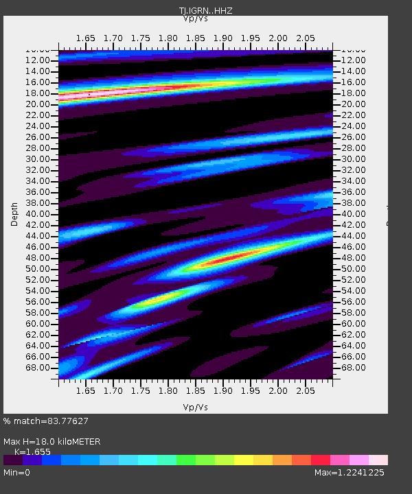
| Estimated Moho Depth: |
18.0 km |
| Estimated Crust Vp/Vs: |
1.65 |
| Assumed Crust Vp: |
6.483 km/s |
| Estimated Crust Vs: |
3.917 km/s |
| Estimated Crust Poisson's Ratio: |
0.21 |
|
| Radial Match: |
83.77627 % |
| Radial Bump: |
400 |
| Transverse Match: |
83.9813 % |
| Transverse Bump: |
400 |
| SOD ConfigId: |
11737051 |
| Insert Time: |
2019-04-27 01:54:54.167 +0000 |
| GWidth: |
2.5 |
| Max Bumps: |
400 |
| Tol: |
0.001 |
|

Signal To Noise
| Channel | StoN | STA | LTA |
| TJ:IGRN: :HHZ:20170410T00:52:58.420022Z | 17.845108 | 2.7463407E-6 | 1.538988E-7 |
| TJ:IGRN: :HHN:20170410T00:52:58.420022Z | 2.4053588 | 7.79807E-9 | 3.2419571E-9 |
| TJ:IGRN: :HHE:20170410T00:52:58.420022Z | 5.4586296 | 8.4635866E-7 | 1.5504966E-7 |
| Arrivals |
| Ps | 1.9 SECOND |
| PpPs | 7.0 SECOND |
| PsPs/PpSs | 8.9 SECOND |


