You are here: Home > Network List > TA - USArray Transportable Network (new EarthScope stations) Stations List
> Station G24K Hadweenzic River, AK, USA > Earthquake Result Viewer
G24K Hadweenzic River, AK, USA - Earthquake Result Viewer
| Earthquake location: |
Philippine Islands Region |
| Earthquake latitude/longitude: |
13.0/125.4 |
| Earthquake time(UTC): |
2017/04/10 (100) 00:43:54 GMT |
| Earthquake Depth: |
8.2 km |
| Earthquake Magnitude: |
5.6 Mww |
| Earthquake Catalog/Contributor: |
NEIC PDE/us |
|
| Network: |
TA USArray Transportable Network (new EarthScope stations) |
| Station: |
G24K Hadweenzic River, AK, USA |
| Lat/Lon: |
66.70 N/147.48 W |
| Elevation: |
503 m |
|
| Distance: |
77.0 deg |
| Az: |
24.061 deg |
| Baz: |
272.636 deg |
| Ray Param: |
0.05060782 |
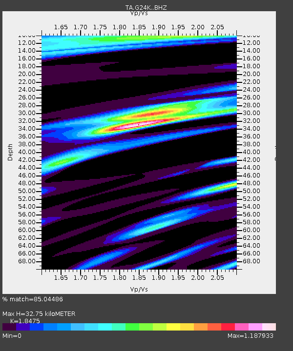
| Estimated Moho Depth: |
32.75 km |
| Estimated Crust Vp/Vs: |
1.85 |
| Assumed Crust Vp: |
6.522 km/s |
| Estimated Crust Vs: |
3.53 km/s |
| Estimated Crust Poisson's Ratio: |
0.29 |
|
| Radial Match: |
85.04486 % |
| Radial Bump: |
400 |
| Transverse Match: |
70.87597 % |
| Transverse Bump: |
400 |
| SOD ConfigId: |
11737051 |
| Insert Time: |
2019-04-27 01:55:24.305 +0000 |
| GWidth: |
2.5 |
| Max Bumps: |
400 |
| Tol: |
0.001 |
|

Signal To Noise
| Channel | StoN | STA | LTA |
| TA:G24K: :BHZ:20170410T00:55:16.19999Z | 4.488236 | 4.577417E-7 | 1.01987E-7 |
| TA:G24K: :BHN:20170410T00:55:16.19999Z | 0.4933616 | 5.3564438E-8 | 1.0857035E-7 |
| TA:G24K: :BHE:20170410T00:55:16.19999Z | 1.6569352 | 1.7178411E-7 | 1.03675816E-7 |
| Arrivals |
| Ps | 4.4 SECOND |
| PpPs | 14 SECOND |
| PsPs/PpSs | 18 SECOND |


