You are here: Home > Network List > TA - USArray Transportable Network (new EarthScope stations) Stations List
> Station J25K Salcha River, AK, USA > Earthquake Result Viewer
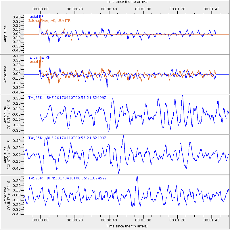
J25K Salcha River, AK, USA - Earthquake Result Viewer
*The percent match for this event was below the threshold and hence no stack was calculated.
| Earthquake location: |
Philippine Islands Region |
| Earthquake latitude/longitude: |
13.0/125.4 |
| Earthquake time(UTC): |
2017/04/10 (100) 00:43:54 GMT |
| Earthquake Depth: |
8.2 km |
| Earthquake Magnitude: |
5.6 Mww |
| Earthquake Catalog/Contributor: |
NEIC PDE/us |
|
| Network: |
TA USArray Transportable Network (new EarthScope stations) |
| Station: |
J25K Salcha River, AK, USA |
| Lat/Lon: |
64.61 N/145.37 W |
| Elevation: |
949 m |
|
| Distance: |
78.0 deg |
| Az: |
26.144 deg |
| Baz: |
275.003 deg |
| Ray Param: |
$rayparam |
*The percent match for this event was below the threshold and hence was not used in the summary stack. |
|
| Radial Match: |
61.31333 % |
| Radial Bump: |
400 |
| Transverse Match: |
56.61295 % |
| Transverse Bump: |
400 |
| SOD ConfigId: |
11737051 |
| Insert Time: |
2019-04-27 01:55:38.063 +0000 |
| GWidth: |
2.5 |
| Max Bumps: |
400 |
| Tol: |
0.001 |
|
Signal To Noise
| Channel | StoN | STA | LTA |
| TA:J25K: :BHZ:20170410T00:55:21.82499Z | 3.3494513 | 3.3875554E-7 | 1.01137616E-7 |
| TA:J25K: :BHN:20170410T00:55:21.82499Z | 1.2867539 | 1.12919956E-7 | 8.775567E-8 |
| TA:J25K: :BHE:20170410T00:55:21.82499Z | 0.9929285 | 9.978128E-8 | 1.004919E-7 |
| Arrivals |
| Ps | |
| PpPs | |
| PsPs/PpSs | |


