You are here: Home > Network List > CI - Caltech Regional Seismic Network Stations List
> Station DAN Danby, California, USA > Earthquake Result Viewer
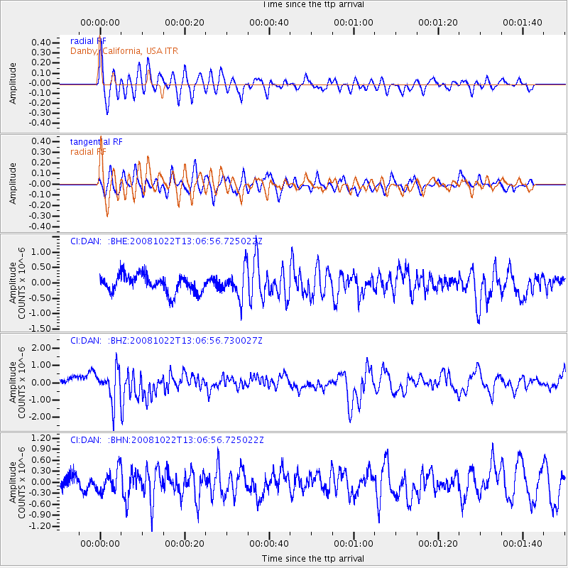
DAN Danby, California, USA - Earthquake Result Viewer
*The percent match for this event was below the threshold and hence no stack was calculated.
| Earthquake location: |
Tonga Islands |
| Earthquake latitude/longitude: |
-18.4/-175.4 |
| Earthquake time(UTC): |
2008/10/22 (296) 12:55:57 GMT |
| Earthquake Depth: |
233 km |
| Earthquake Magnitude: |
5.9 MB, 6.4 MW, 6.3 MW |
| Earthquake Catalog/Contributor: |
WHDF/NEIC |
|
| Network: |
CI Caltech Regional Seismic Network |
| Station: |
DAN Danby, California, USA |
| Lat/Lon: |
34.64 N/115.38 W |
| Elevation: |
398 m |
|
| Distance: |
77.6 deg |
| Az: |
46.955 deg |
| Baz: |
237.299 deg |
| Ray Param: |
$rayparam |
*The percent match for this event was below the threshold and hence was not used in the summary stack. |
|
| Radial Match: |
64.46506 % |
| Radial Bump: |
400 |
| Transverse Match: |
63.88227 % |
| Transverse Bump: |
400 |
| SOD ConfigId: |
2556 |
| Insert Time: |
2010-02-26 01:06:13.240 +0000 |
| GWidth: |
2.5 |
| Max Bumps: |
400 |
| Tol: |
0.001 |
|
Signal To Noise
| Channel | StoN | STA | LTA |
| CI:DAN: :BHZ:20081022T13:06:56.730027Z | 2.898847 | 9.1876893E-7 | 3.1694287E-7 |
| CI:DAN: :BHN:20081022T13:06:56.725022Z | 1.4670938 | 3.0704012E-7 | 2.092846E-7 |
| CI:DAN: :BHE:20081022T13:06:56.725022Z | 1.6744579 | 4.790311E-7 | 2.860813E-7 |
| Arrivals |
| Ps | |
| PpPs | |
| PsPs/PpSs | |


