You are here: Home > Network List > G - GEOSCOPE Stations List
> Station RER Riviere de l'Est, La Reunion (Indian Ocean) > Earthquake Result Viewer
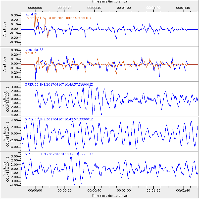
RER Riviere de l'Est, La Reunion (Indian Ocean) - Earthquake Result Viewer
*The percent match for this event was below the threshold and hence no stack was calculated.
| Earthquake location: |
Philippine Islands Region |
| Earthquake latitude/longitude: |
5.7/127.2 |
| Earthquake time(UTC): |
2017/04/10 (100) 10:38:48 GMT |
| Earthquake Depth: |
13 km |
| Earthquake Magnitude: |
5.8 Mww |
| Earthquake Catalog/Contributor: |
NEIC PDE/us |
|
| Network: |
G GEOSCOPE |
| Station: |
RER Riviere de l'Est, La Reunion (Indian Ocean) |
| Lat/Lon: |
21.16 S/55.75 E |
| Elevation: |
834 m |
|
| Distance: |
74.9 deg |
| Az: |
246.414 deg |
| Baz: |
77.711 deg |
| Ray Param: |
$rayparam |
*The percent match for this event was below the threshold and hence was not used in the summary stack. |
|
| Radial Match: |
58.80338 % |
| Radial Bump: |
400 |
| Transverse Match: |
76.1741 % |
| Transverse Bump: |
376 |
| SOD ConfigId: |
11737051 |
| Insert Time: |
2019-04-27 02:00:24.017 +0000 |
| GWidth: |
2.5 |
| Max Bumps: |
400 |
| Tol: |
0.001 |
|
Signal To Noise
| Channel | StoN | STA | LTA |
| G:RER:00:BHZ:20170410T10:49:57.399001Z | 2.3733892 | 3.1718284E-6 | 1.3364131E-6 |
| G:RER:00:BHN:20170410T10:49:57.399001Z | 0.81315255 | 8.319311E-7 | 1.0230935E-6 |
| G:RER:00:BHE:20170410T10:49:57.399001Z | 1.3914653 | 1.7768726E-6 | 1.2769794E-6 |
| Arrivals |
| Ps | |
| PpPs | |
| PsPs/PpSs | |


