You are here: Home > Network List > TA - USArray Transportable Network (new EarthScope stations) Stations List
> Station D23K Nanushuk River, AK USA > Earthquake Result Viewer
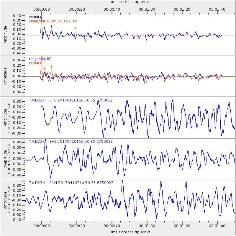
D23K Nanushuk River, AK USA - Earthquake Result Viewer
*The percent match for this event was below the threshold and hence no stack was calculated.
| Earthquake location: |
Philippine Islands Region |
| Earthquake latitude/longitude: |
5.7/127.2 |
| Earthquake time(UTC): |
2017/04/10 (100) 10:38:48 GMT |
| Earthquake Depth: |
13 km |
| Earthquake Magnitude: |
5.8 Mww |
| Earthquake Catalog/Contributor: |
NEIC PDE/us |
|
| Network: |
TA USArray Transportable Network (new EarthScope stations) |
| Station: |
D23K Nanushuk River, AK USA |
| Lat/Lon: |
68.97 N/150.68 W |
| Elevation: |
406 m |
|
| Distance: |
81.9 deg |
| Az: |
21.176 deg |
| Baz: |
264.688 deg |
| Ray Param: |
$rayparam |
*The percent match for this event was below the threshold and hence was not used in the summary stack. |
|
| Radial Match: |
64.28769 % |
| Radial Bump: |
400 |
| Transverse Match: |
57.72341 % |
| Transverse Bump: |
400 |
| SOD ConfigId: |
11737051 |
| Insert Time: |
2019-04-27 02:02:42.171 +0000 |
| GWidth: |
2.5 |
| Max Bumps: |
400 |
| Tol: |
0.001 |
|
Signal To Noise
| Channel | StoN | STA | LTA |
| TA:D23K: :BHZ:20170410T10:50:35.675002Z | 5.2346425 | 4.8703714E-7 | 9.304115E-8 |
| TA:D23K: :BHN:20170410T10:50:35.675002Z | 2.4975328 | 1.3313559E-7 | 5.3306838E-8 |
| TA:D23K: :BHE:20170410T10:50:35.675002Z | 1.3301607 | 1.7018321E-7 | 1.2794183E-7 |
| Arrivals |
| Ps | |
| PpPs | |
| PsPs/PpSs | |


