You are here: Home > Network List > TA - USArray Transportable Network (new EarthScope stations) Stations List
> Station E23K Chandalar, AK, USA > Earthquake Result Viewer
E23K Chandalar, AK, USA - Earthquake Result Viewer
| Earthquake location: |
Philippine Islands Region |
| Earthquake latitude/longitude: |
5.7/127.2 |
| Earthquake time(UTC): |
2017/04/10 (100) 10:38:48 GMT |
| Earthquake Depth: |
13 km |
| Earthquake Magnitude: |
5.8 Mww |
| Earthquake Catalog/Contributor: |
NEIC PDE/us |
|
| Network: |
TA USArray Transportable Network (new EarthScope stations) |
| Station: |
E23K Chandalar, AK, USA |
| Lat/Lon: |
68.06 N/149.62 W |
| Elevation: |
1084 m |
|
| Distance: |
82.2 deg |
| Az: |
22.126 deg |
| Baz: |
265.809 deg |
| Ray Param: |
0.0470437 |
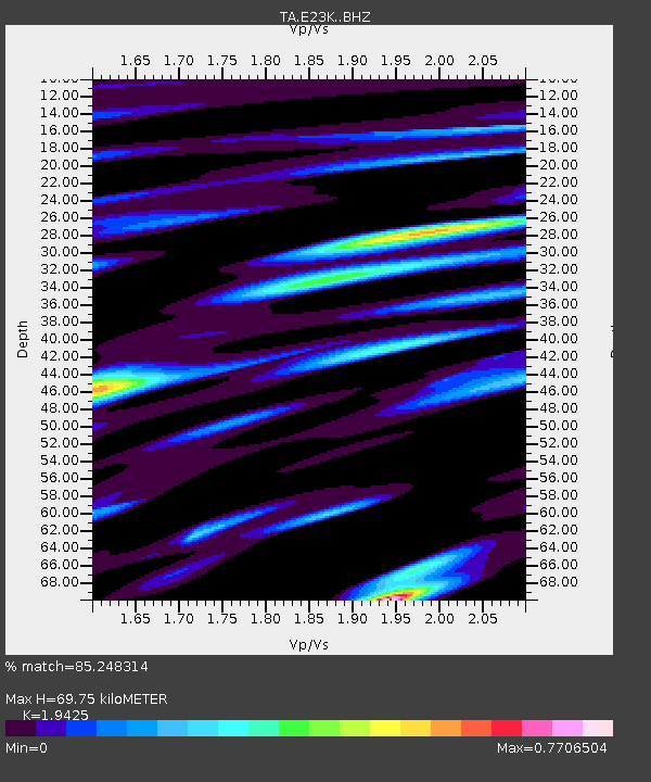
| Estimated Moho Depth: |
69.75 km |
| Estimated Crust Vp/Vs: |
1.94 |
| Assumed Crust Vp: |
6.316 km/s |
| Estimated Crust Vs: |
3.252 km/s |
| Estimated Crust Poisson's Ratio: |
0.32 |
|
| Radial Match: |
85.248314 % |
| Radial Bump: |
400 |
| Transverse Match: |
78.05583 % |
| Transverse Bump: |
400 |
| SOD ConfigId: |
11737051 |
| Insert Time: |
2019-04-27 02:02:46.162 +0000 |
| GWidth: |
2.5 |
| Max Bumps: |
400 |
| Tol: |
0.001 |
|

Signal To Noise
| Channel | StoN | STA | LTA |
| TA:E23K: :BHZ:20170410T10:50:37.325027Z | 4.4509125 | 4.5161156E-7 | 1.01464934E-7 |
| TA:E23K: :BHN:20170410T10:50:37.325027Z | 0.58393514 | 3.976545E-8 | 6.8099084E-8 |
| TA:E23K: :BHE:20170410T10:50:37.325027Z | 3.8960986 | 1.8163614E-7 | 4.6620006E-8 |
| Arrivals |
| Ps | 11 SECOND |
| PpPs | 32 SECOND |
| PsPs/PpSs | 42 SECOND |


