You are here: Home > Network List > TA - USArray Transportable Network (new EarthScope stations) Stations List
> Station O17K Koliganek, Bristol Bay, AK, USA > Earthquake Result Viewer
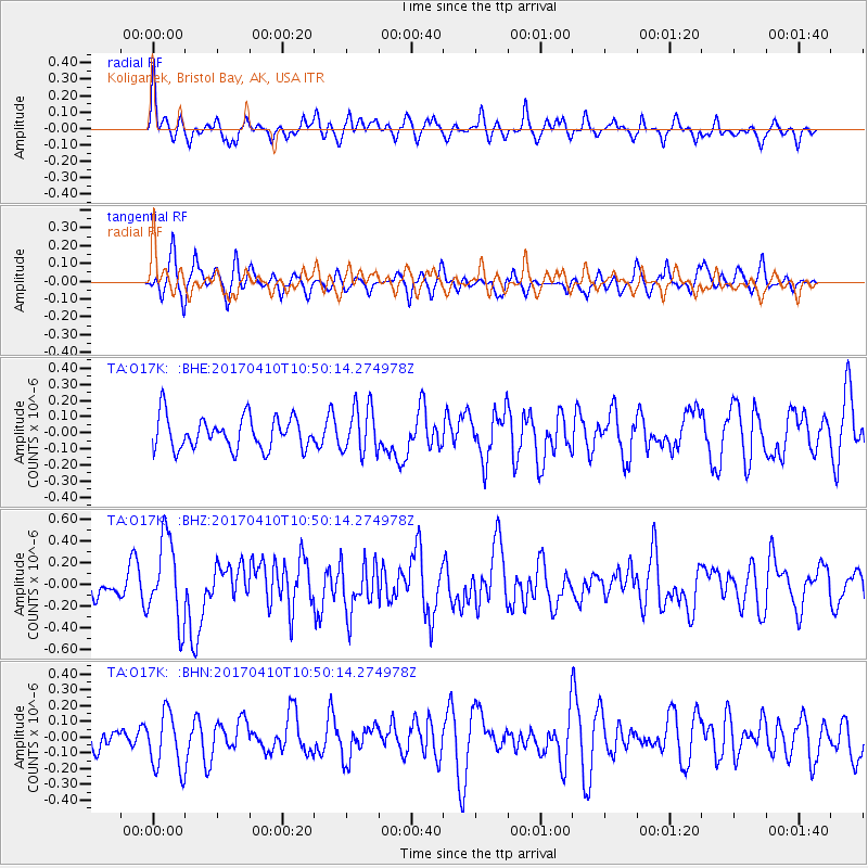
O17K Koliganek, Bristol Bay, AK, USA - Earthquake Result Viewer
*The percent match for this event was below the threshold and hence no stack was calculated.
| Earthquake location: |
Philippine Islands Region |
| Earthquake latitude/longitude: |
5.7/127.2 |
| Earthquake time(UTC): |
2017/04/10 (100) 10:38:48 GMT |
| Earthquake Depth: |
13 km |
| Earthquake Magnitude: |
5.8 Mww |
| Earthquake Catalog/Contributor: |
NEIC PDE/us |
|
| Network: |
TA USArray Transportable Network (new EarthScope stations) |
| Station: |
O17K Koliganek, Bristol Bay, AK, USA |
| Lat/Lon: |
59.77 N/157.09 W |
| Elevation: |
156 m |
|
| Distance: |
77.9 deg |
| Az: |
30.092 deg |
| Baz: |
260.459 deg |
| Ray Param: |
$rayparam |
*The percent match for this event was below the threshold and hence was not used in the summary stack. |
|
| Radial Match: |
62.430187 % |
| Radial Bump: |
349 |
| Transverse Match: |
50.74591 % |
| Transverse Bump: |
375 |
| SOD ConfigId: |
11737051 |
| Insert Time: |
2019-04-27 02:03:29.653 +0000 |
| GWidth: |
2.5 |
| Max Bumps: |
400 |
| Tol: |
0.001 |
|
Signal To Noise
| Channel | StoN | STA | LTA |
| TA:O17K: :BHZ:20170410T10:50:14.274978Z | 3.0444937 | 3.8116136E-7 | 1.2519696E-7 |
| TA:O17K: :BHN:20170410T10:50:14.274978Z | 1.3285581 | 1.8215361E-7 | 1.3710624E-7 |
| TA:O17K: :BHE:20170410T10:50:14.274978Z | 1.4540071 | 1.455506E-7 | 1.0010309E-7 |
| Arrivals |
| Ps | |
| PpPs | |
| PsPs/PpSs | |


