You are here: Home > Network List > CI - Caltech Regional Seismic Network Stations List
> Station DAN Danby, California, USA > Earthquake Result Viewer
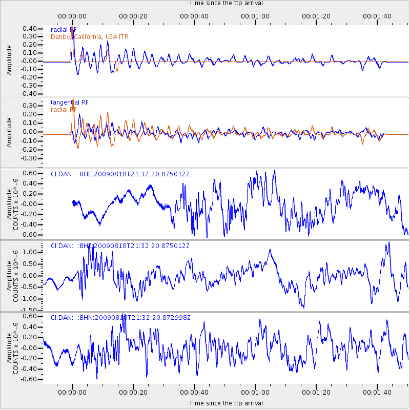
DAN Danby, California, USA - Earthquake Result Viewer
*The percent match for this event was below the threshold and hence no stack was calculated.
| Earthquake location: |
South Of Fiji Islands |
| Earthquake latitude/longitude: |
-26.1/-178.4 |
| Earthquake time(UTC): |
2009/08/18 (230) 21:20:47 GMT |
| Earthquake Depth: |
270 km |
| Earthquake Magnitude: |
5.5 MB, 6.3 MW, 6.3 MW |
| Earthquake Catalog/Contributor: |
WHDF/NEIC |
|
| Network: |
CI Caltech Regional Seismic Network |
| Station: |
DAN Danby, California, USA |
| Lat/Lon: |
34.64 N/115.38 W |
| Elevation: |
398 m |
|
| Distance: |
84.9 deg |
| Az: |
47.535 deg |
| Baz: |
233.583 deg |
| Ray Param: |
$rayparam |
*The percent match for this event was below the threshold and hence was not used in the summary stack. |
|
| Radial Match: |
53.613503 % |
| Radial Bump: |
400 |
| Transverse Match: |
43.885056 % |
| Transverse Bump: |
400 |
| SOD ConfigId: |
2622 |
| Insert Time: |
2010-02-26 01:06:15.034 +0000 |
| GWidth: |
2.5 |
| Max Bumps: |
400 |
| Tol: |
0.001 |
|
Signal To Noise
| Channel | StoN | STA | LTA |
| CI:DAN: :BHZ:20090818T21:32:20.875012Z | 1.0860533 | 3.5389118E-7 | 3.2585066E-7 |
| CI:DAN: :BHN:20090818T21:32:20.872998Z | 1.905408 | 2.671824E-7 | 1.402232E-7 |
| CI:DAN: :BHE:20090818T21:32:20.875012Z | 0.94907403 | 1.6915347E-7 | 1.7823E-7 |
| Arrivals |
| Ps | |
| PpPs | |
| PsPs/PpSs | |


