You are here: Home > Network List > GO - National Seismic Network of Georgia Stations List
> Station AKH Akhalkalaki > Earthquake Result Viewer
AKH Akhalkalaki - Earthquake Result Viewer
| Earthquake location: |
Philippine Islands Region |
| Earthquake latitude/longitude: |
5.7/127.1 |
| Earthquake time(UTC): |
2017/04/11 (101) 14:42:16 GMT |
| Earthquake Depth: |
9.6 km |
| Earthquake Magnitude: |
5.6 mb |
| Earthquake Catalog/Contributor: |
NEIC PDE/us |
|
| Network: |
GO National Seismic Network of Georgia |
| Station: |
AKH Akhalkalaki |
| Lat/Lon: |
41.41 N/43.49 E |
| Elevation: |
1720 m |
|
| Distance: |
81.5 deg |
| Az: |
310.9 deg |
| Baz: |
89.955 deg |
| Ray Param: |
0.04756117 |
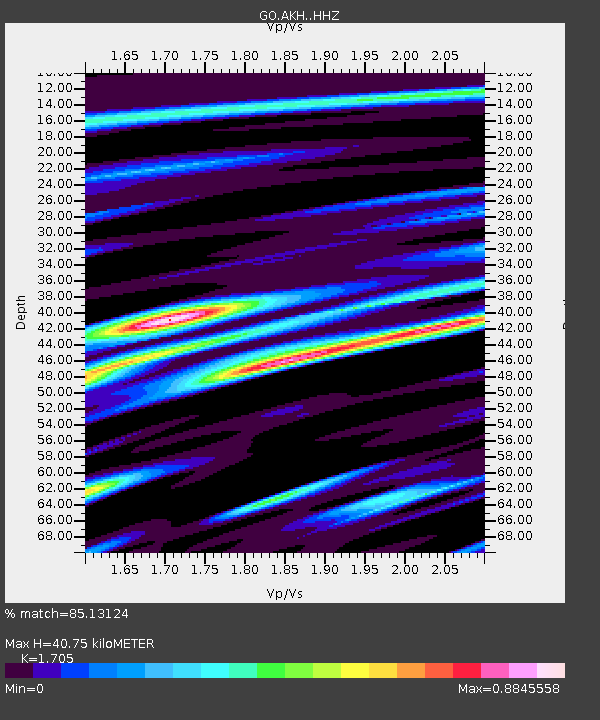
| Estimated Moho Depth: |
40.75 km |
| Estimated Crust Vp/Vs: |
1.71 |
| Assumed Crust Vp: |
6.419 km/s |
| Estimated Crust Vs: |
3.765 km/s |
| Estimated Crust Poisson's Ratio: |
0.24 |
|
| Radial Match: |
85.13124 % |
| Radial Bump: |
400 |
| Transverse Match: |
69.87635 % |
| Transverse Bump: |
400 |
| SOD ConfigId: |
11737051 |
| Insert Time: |
2019-04-27 02:07:27.459 +0000 |
| GWidth: |
2.5 |
| Max Bumps: |
400 |
| Tol: |
0.001 |
|

Signal To Noise
| Channel | StoN | STA | LTA |
| GO:AKH: :HHZ:20170411T14:54:01.999983Z | 5.708531 | 1.1021516E-6 | 1.9307097E-7 |
| GO:AKH: :HHN:20170411T14:54:01.999983Z | 0.5795021 | 2.0200144E-7 | 3.4857757E-7 |
| GO:AKH: :HHE:20170411T14:54:01.999983Z | 1.2088454 | 3.2949657E-7 | 2.725713E-7 |
| Arrivals |
| Ps | 4.6 SECOND |
| PpPs | 17 SECOND |
| PsPs/PpSs | 21 SECOND |


