You are here: Home > Network List > TA - USArray Transportable Network (new EarthScope stations) Stations List
> Station U26A Atchley Ranch, Grenville, NM, USA > Earthquake Result Viewer
U26A Atchley Ranch, Grenville, NM, USA - Earthquake Result Viewer
| Earthquake location: |
Santiago Del Estero Prov., Arg. |
| Earthquake latitude/longitude: |
-26.7/-63.2 |
| Earthquake time(UTC): |
2008/09/03 (247) 11:25:14 GMT |
| Earthquake Depth: |
570 km |
| Earthquake Magnitude: |
5.9 MB, 6.3 MW, 6.3 MW |
| Earthquake Catalog/Contributor: |
WHDF/NEIC |
|
| Network: |
TA USArray Transportable Network (new EarthScope stations) |
| Station: |
U26A Atchley Ranch, Grenville, NM, USA |
| Lat/Lon: |
36.39 N/103.74 W |
| Elevation: |
1861 m |
|
| Distance: |
73.5 deg |
| Az: |
326.856 deg |
| Baz: |
142.699 deg |
| Ray Param: |
0.051093183 |
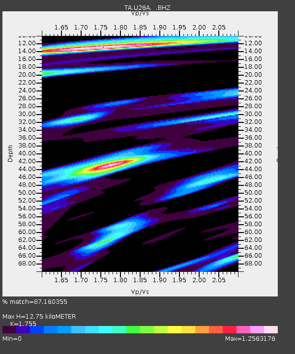
| Estimated Moho Depth: |
12.75 km |
| Estimated Crust Vp/Vs: |
1.75 |
| Assumed Crust Vp: |
6.306 km/s |
| Estimated Crust Vs: |
3.593 km/s |
| Estimated Crust Poisson's Ratio: |
0.26 |
|
| Radial Match: |
87.160355 % |
| Radial Bump: |
392 |
| Transverse Match: |
65.57938 % |
| Transverse Bump: |
378 |
| SOD ConfigId: |
2658 |
| Insert Time: |
2010-03-05 22:54:46.609 +0000 |
| GWidth: |
2.5 |
| Max Bumps: |
400 |
| Tol: |
0.001 |
|
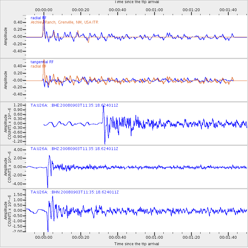
Signal To Noise
| Channel | StoN | STA | LTA |
| TA:U26A: :BHZ:20080903T11:35:18.624011Z | 10.355611 | 1.5571834E-6 | 1.50371E-7 |
| TA:U26A: :BHN:20080903T11:35:18.624011Z | 6.5526085 | 6.900043E-7 | 1.05302234E-7 |
| TA:U26A: :BHE:20080903T11:35:18.624011Z | 5.967131 | 5.007049E-7 | 8.391049E-8 |
| Arrivals |
| Ps | 1.6 SECOND |
| PpPs | 5.4 SECOND |
| PsPs/PpSs | 7.0 SECOND |


