You are here: Home > Network List > TA - USArray Transportable Network (new EarthScope stations) Stations List
> Station U26A Atchley Ranch, Grenville, NM, USA > Earthquake Result Viewer
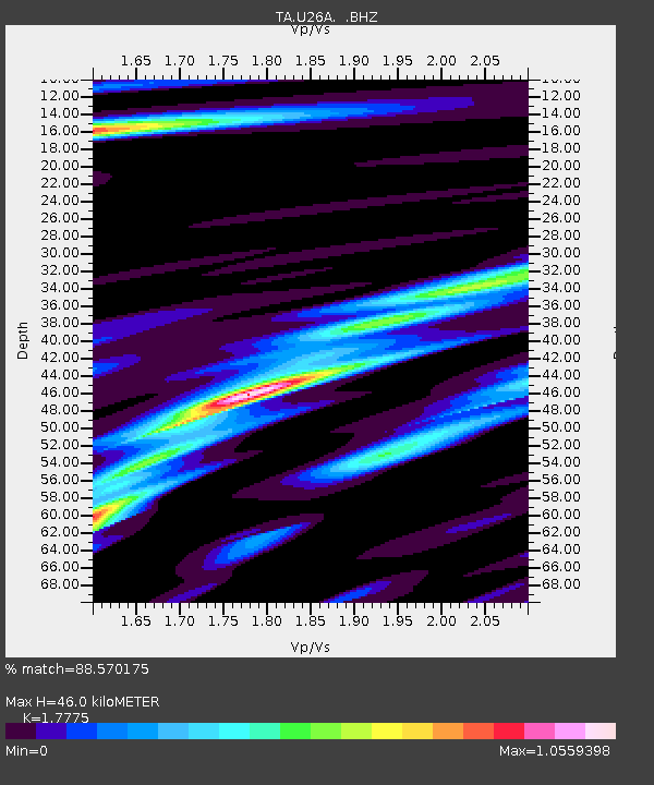
U26A Atchley Ranch, Grenville, NM, USA - Earthquake Result Viewer
| Earthquake location: |
South Of Panama |
| Earthquake latitude/longitude: |
5.0/-82.7 |
| Earthquake time(UTC): |
2008/06/17 (169) 17:42:09 GMT |
| Earthquake Depth: |
10 km |
| Earthquake Magnitude: |
5.6 MB, 5.3 MS, 5.9 MW, 5.9 MW |
| Earthquake Catalog/Contributor: |
WHDF/NEIC |
|
| Network: |
TA USArray Transportable Network (new EarthScope stations) |
| Station: |
U26A Atchley Ranch, Grenville, NM, USA |
| Lat/Lon: |
36.39 N/103.74 W |
| Elevation: |
1861 m |
|
| Distance: |
36.8 deg |
| Az: |
330.974 deg |
| Baz: |
143.195 deg |
| Ray Param: |
0.07650708 |
| Estimated Moho Depth: |
46.0 km |
| Estimated Crust Vp/Vs: |
1.78 |
| Assumed Crust Vp: |
6.306 km/s |
| Estimated Crust Vs: |
3.548 km/s |
| Estimated Crust Poisson's Ratio: |
0.27 |
|
| Radial Match: |
88.570175 % |
| Radial Bump: |
313 |
| Transverse Match: |
59.33372 % |
| Transverse Bump: |
400 |
| SOD ConfigId: |
2504 |
| Insert Time: |
2010-03-05 22:54:47.728 +0000 |
| GWidth: |
2.5 |
| Max Bumps: |
400 |
| Tol: |
0.001 |
|

Signal To Noise
| Channel | StoN | STA | LTA |
| TA:U26A: :BHZ:20080617T17:48:46.37401Z | 11.417056 | 6.273942E-7 | 5.4952363E-8 |
| TA:U26A: :BHN:20080617T17:48:46.37401Z | 5.280724 | 3.606972E-7 | 6.8304495E-8 |
| TA:U26A: :BHE:20080617T17:48:46.37401Z | 5.000764 | 2.792319E-7 | 5.5837848E-8 |
| Arrivals |
| Ps | 6.1 SECOND |
| PpPs | 19 SECOND |
| PsPs/PpSs | 25 SECOND |


