You are here: Home > Network List > TA - USArray Transportable Network (new EarthScope stations) Stations List
> Station F22K John River, AK, USA > Earthquake Result Viewer
F22K John River, AK, USA - Earthquake Result Viewer
| Earthquake location: |
Philippine Islands Region |
| Earthquake latitude/longitude: |
5.7/127.1 |
| Earthquake time(UTC): |
2017/04/11 (101) 14:42:16 GMT |
| Earthquake Depth: |
9.6 km |
| Earthquake Magnitude: |
5.6 mb |
| Earthquake Catalog/Contributor: |
NEIC PDE/us |
|
| Network: |
TA USArray Transportable Network (new EarthScope stations) |
| Station: |
F22K John River, AK, USA |
| Lat/Lon: |
67.51 N/152.18 W |
| Elevation: |
546 m |
|
| Distance: |
81.2 deg |
| Az: |
22.595 deg |
| Baz: |
263.602 deg |
| Ray Param: |
0.047729358 |
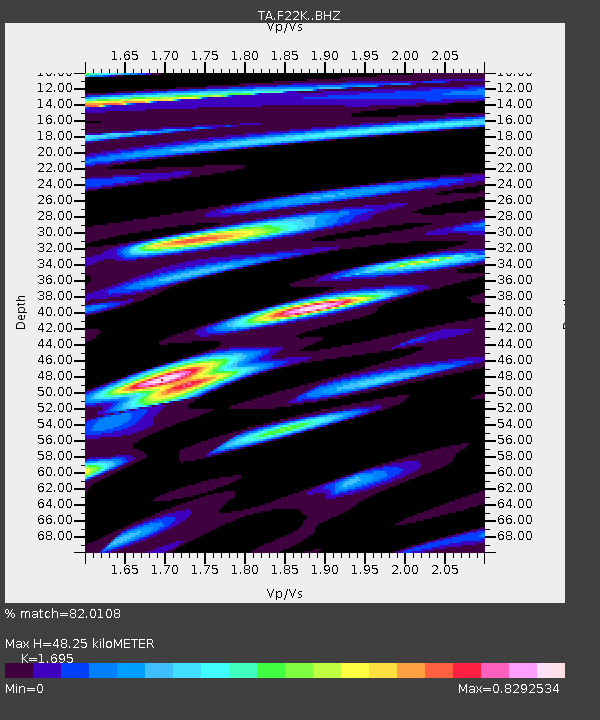
| Estimated Moho Depth: |
48.25 km |
| Estimated Crust Vp/Vs: |
1.70 |
| Assumed Crust Vp: |
6.455 km/s |
| Estimated Crust Vs: |
3.808 km/s |
| Estimated Crust Poisson's Ratio: |
0.23 |
|
| Radial Match: |
82.0108 % |
| Radial Bump: |
400 |
| Transverse Match: |
64.58446 % |
| Transverse Bump: |
400 |
| SOD ConfigId: |
11737051 |
| Insert Time: |
2019-04-27 02:09:36.960 +0000 |
| GWidth: |
2.5 |
| Max Bumps: |
400 |
| Tol: |
0.001 |
|

Signal To Noise
| Channel | StoN | STA | LTA |
| TA:F22K: :BHZ:20170411T14:54:00.674971Z | 6.9303536 | 4.1975622E-7 | 6.056779E-8 |
| TA:F22K: :BHN:20170411T14:54:00.674971Z | 2.0477328 | 1.2949297E-7 | 6.3237245E-8 |
| TA:F22K: :BHE:20170411T14:54:00.674971Z | 2.1763241 | 1.1363738E-7 | 5.2215285E-8 |
| Arrivals |
| Ps | 5.3 SECOND |
| PpPs | 20 SECOND |
| PsPs/PpSs | 25 SECOND |


