You are here: Home > Network List > TA - USArray Transportable Network (new EarthScope stations) Stations List
> Station J20K Nowitna River, AK, USA > Earthquake Result Viewer
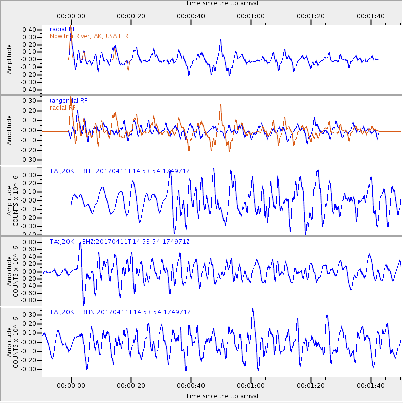
J20K Nowitna River, AK, USA - Earthquake Result Viewer
*The percent match for this event was below the threshold and hence no stack was calculated.
| Earthquake location: |
Philippine Islands Region |
| Earthquake latitude/longitude: |
5.7/127.1 |
| Earthquake time(UTC): |
2017/04/11 (101) 14:42:16 GMT |
| Earthquake Depth: |
9.6 km |
| Earthquake Magnitude: |
5.6 mb |
| Earthquake Catalog/Contributor: |
NEIC PDE/us |
|
| Network: |
TA USArray Transportable Network (new EarthScope stations) |
| Station: |
J20K Nowitna River, AK, USA |
| Lat/Lon: |
64.18 N/154.15 W |
| Elevation: |
314 m |
|
| Distance: |
80.0 deg |
| Az: |
25.86 deg |
| Baz: |
262.34 deg |
| Ray Param: |
$rayparam |
*The percent match for this event was below the threshold and hence was not used in the summary stack. |
|
| Radial Match: |
74.894165 % |
| Radial Bump: |
311 |
| Transverse Match: |
60.026978 % |
| Transverse Bump: |
400 |
| SOD ConfigId: |
11737051 |
| Insert Time: |
2019-04-27 02:09:53.766 +0000 |
| GWidth: |
2.5 |
| Max Bumps: |
400 |
| Tol: |
0.001 |
|
Signal To Noise
| Channel | StoN | STA | LTA |
| TA:J20K: :BHZ:20170411T14:53:54.174971Z | 4.707842 | 4.2998045E-7 | 9.133281E-8 |
| TA:J20K: :BHN:20170411T14:53:54.174971Z | 1.2069442 | 8.010829E-8 | 6.637282E-8 |
| TA:J20K: :BHE:20170411T14:53:54.174971Z | 1.8717734 | 1.9931107E-7 | 1.0648248E-7 |
| Arrivals |
| Ps | |
| PpPs | |
| PsPs/PpSs | |


