You are here: Home > Network List > TA - USArray Transportable Network (new EarthScope stations) Stations List
> Station O17K Koliganek, Bristol Bay, AK, USA > Earthquake Result Viewer
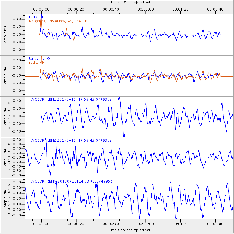
O17K Koliganek, Bristol Bay, AK, USA - Earthquake Result Viewer
*The percent match for this event was below the threshold and hence no stack was calculated.
| Earthquake location: |
Philippine Islands Region |
| Earthquake latitude/longitude: |
5.7/127.1 |
| Earthquake time(UTC): |
2017/04/11 (101) 14:42:16 GMT |
| Earthquake Depth: |
9.6 km |
| Earthquake Magnitude: |
5.6 mb |
| Earthquake Catalog/Contributor: |
NEIC PDE/us |
|
| Network: |
TA USArray Transportable Network (new EarthScope stations) |
| Station: |
O17K Koliganek, Bristol Bay, AK, USA |
| Lat/Lon: |
59.77 N/157.09 W |
| Elevation: |
156 m |
|
| Distance: |
78.0 deg |
| Az: |
30.1 deg |
| Baz: |
260.548 deg |
| Ray Param: |
$rayparam |
*The percent match for this event was below the threshold and hence was not used in the summary stack. |
|
| Radial Match: |
79.83632 % |
| Radial Bump: |
400 |
| Transverse Match: |
64.47992 % |
| Transverse Bump: |
400 |
| SOD ConfigId: |
11737051 |
| Insert Time: |
2019-04-27 02:10:17.252 +0000 |
| GWidth: |
2.5 |
| Max Bumps: |
400 |
| Tol: |
0.001 |
|
Signal To Noise
| Channel | StoN | STA | LTA |
| TA:O17K: :BHZ:20170411T14:53:43.074995Z | 1.6444714 | 4.0604334E-7 | 2.469142E-7 |
| TA:O17K: :BHN:20170411T14:53:43.074995Z | 0.94823694 | 1.11970124E-7 | 1.1808243E-7 |
| TA:O17K: :BHE:20170411T14:53:43.074995Z | 0.7929293 | 1.3153819E-7 | 1.6588892E-7 |
| Arrivals |
| Ps | |
| PpPs | |
| PsPs/PpSs | |


