You are here: Home > Network List > TA - USArray Transportable Network (new EarthScope stations) Stations List
> Station U26A Atchley Ranch, Grenville, NM, USA > Earthquake Result Viewer
U26A Atchley Ranch, Grenville, NM, USA - Earthquake Result Viewer
| Earthquake location: |
Colombia |
| Earthquake latitude/longitude: |
4.8/-75.5 |
| Earthquake time(UTC): |
2008/09/13 (257) 09:32:01 GMT |
| Earthquake Depth: |
133 km |
| Earthquake Magnitude: |
5.9 MB, 5.7 MW, 5.7 MW |
| Earthquake Catalog/Contributor: |
WHDF/NEIC |
|
| Network: |
TA USArray Transportable Network (new EarthScope stations) |
| Station: |
U26A Atchley Ranch, Grenville, NM, USA |
| Lat/Lon: |
36.39 N/103.74 W |
| Elevation: |
1861 m |
|
| Distance: |
40.8 deg |
| Az: |
324.233 deg |
| Baz: |
133.787 deg |
| Ray Param: |
0.07372253 |
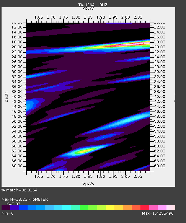
| Estimated Moho Depth: |
18.25 km |
| Estimated Crust Vp/Vs: |
2.07 |
| Assumed Crust Vp: |
6.306 km/s |
| Estimated Crust Vs: |
3.046 km/s |
| Estimated Crust Poisson's Ratio: |
0.35 |
|
| Radial Match: |
86.3164 % |
| Radial Bump: |
400 |
| Transverse Match: |
79.16494 % |
| Transverse Bump: |
400 |
| SOD ConfigId: |
2560 |
| Insert Time: |
2010-03-05 22:55:14.605 +0000 |
| GWidth: |
2.5 |
| Max Bumps: |
400 |
| Tol: |
0.001 |
|

Signal To Noise
| Channel | StoN | STA | LTA |
| TA:U26A: :BHZ:20080913T09:38:59.04899Z | 12.676393 | 2.2857935E-6 | 1.8031892E-7 |
| TA:U26A: :BHN:20080913T09:38:59.04899Z | 4.595511 | 1.0437852E-6 | 2.271315E-7 |
| TA:U26A: :BHE:20080913T09:38:59.04899Z | 5.411543 | 1.1797043E-6 | 2.1799778E-7 |
| Arrivals |
| Ps | 3.3 SECOND |
| PpPs | 8.4 SECOND |
| PsPs/PpSs | 12 SECOND |


