You are here: Home > Network List > TA - USArray Transportable Network (new EarthScope stations) Stations List
> Station U26A Atchley Ranch, Grenville, NM, USA > Earthquake Result Viewer
U26A Atchley Ranch, Grenville, NM, USA - Earthquake Result Viewer

| Earthquake location: |
East Of Severnaya Zemlya |
| Earthquake latitude/longitude: |
81.6/119.5 |
| Earthquake time(UTC): |
2009/10/07 (280) 20:52:13 GMT |
| Earthquake Depth: |
8.0 km |
| Earthquake Magnitude: |
5.7 MB, 5.1 MS, 5.8 MW, 5.8 MW |
| Earthquake Catalog/Contributor: |
WHDF/NEIC |
|
| Network: |
TA USArray Transportable Network (new EarthScope stations) |
| Station: |
U26A Atchley Ranch, Grenville, NM, USA |
| Lat/Lon: |
36.39 N/103.74 W |
| Elevation: |
1861 m |
|
| Distance: |
60.2 deg |
| Az: |
39.619 deg |
| Baz: |
353.304 deg |
| Ray Param: |
0.06172247 |
| Estimated Moho Depth: |
18.5 km |
| Estimated Crust Vp/Vs: |
2.00 |
| Assumed Crust Vp: |
6.306 km/s |
| Estimated Crust Vs: |
3.157 km/s |
| Estimated Crust Poisson's Ratio: |
0.33 |
|
| Radial Match: |
80.80461 % |
| Radial Bump: |
400 |
| Transverse Match: |
69.24232 % |
| Transverse Bump: |
400 |
| SOD ConfigId: |
2622 |
| Insert Time: |
2010-03-05 22:55:48.556 +0000 |
| GWidth: |
2.5 |
| Max Bumps: |
400 |
| Tol: |
0.001 |
|
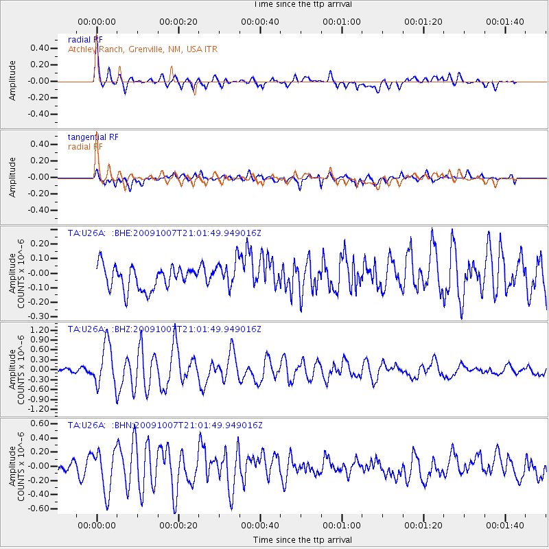
Signal To Noise
| Channel | StoN | STA | LTA |
| TA:U26A: :BHZ:20091007T21:01:49.949016Z | 9.262521 | 6.619683E-7 | 7.1467404E-8 |
| TA:U26A: :BHN:20091007T21:01:49.949016Z | 3.015601 | 3.0024722E-7 | 9.9564645E-8 |
| TA:U26A: :BHE:20091007T21:01:49.949016Z | 1.2310368 | 9.705167E-8 | 7.8837346E-8 |
| Arrivals |
| Ps | 3.0 SECOND |
| PpPs | 8.5 SECOND |
| PsPs/PpSs | 11 SECOND |


