You are here: Home > Network List > TA - USArray Transportable Network (new EarthScope stations) Stations List
> Station U26A Atchley Ranch, Grenville, NM, USA > Earthquake Result Viewer
U26A Atchley Ranch, Grenville, NM, USA - Earthquake Result Viewer
| Earthquake location: |
Northern Mid-Atlantic Ridge |
| Earthquake latitude/longitude: |
23.9/-46.1 |
| Earthquake time(UTC): |
2009/06/06 (157) 20:33:28 GMT |
| Earthquake Depth: |
14 km |
| Earthquake Magnitude: |
6.0 MB, 5.7 MS, 6.0 MW, 6.0 MW |
| Earthquake Catalog/Contributor: |
WHDF/NEIC |
|
| Network: |
TA USArray Transportable Network (new EarthScope stations) |
| Station: |
U26A Atchley Ranch, Grenville, NM, USA |
| Lat/Lon: |
36.39 N/103.74 W |
| Elevation: |
1861 m |
|
| Distance: |
50.7 deg |
| Az: |
298.309 deg |
| Baz: |
87.401 deg |
| Ray Param: |
0.06785258 |
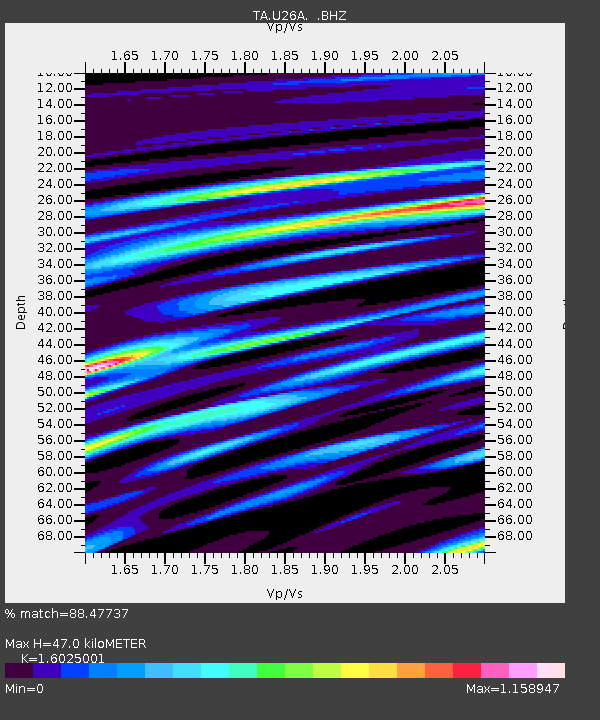
| Estimated Moho Depth: |
47.0 km |
| Estimated Crust Vp/Vs: |
1.60 |
| Assumed Crust Vp: |
6.306 km/s |
| Estimated Crust Vs: |
3.935 km/s |
| Estimated Crust Poisson's Ratio: |
0.18 |
|
| Radial Match: |
88.47737 % |
| Radial Bump: |
400 |
| Transverse Match: |
64.32667 % |
| Transverse Bump: |
400 |
| SOD ConfigId: |
2648 |
| Insert Time: |
2010-03-05 22:55:57.295 +0000 |
| GWidth: |
2.5 |
| Max Bumps: |
400 |
| Tol: |
0.001 |
|

Signal To Noise
| Channel | StoN | STA | LTA |
| TA:U26A: :BHZ:20090606T20:41:57.050001Z | 4.7893953 | 2.6047664E-7 | 5.438612E-8 |
| TA:U26A: :BHN:20090606T20:41:57.050001Z | 0.78472996 | 7.161351E-8 | 9.1258805E-8 |
| TA:U26A: :BHE:20090606T20:41:57.050001Z | 2.3934584 | 2.0438343E-7 | 8.5392514E-8 |
| Arrivals |
| Ps | 4.8 SECOND |
| PpPs | 18 SECOND |
| PsPs/PpSs | 23 SECOND |


