You are here: Home > Network List > TA - USArray Transportable Network (new EarthScope stations) Stations List
> Station U26A Atchley Ranch, Grenville, NM, USA > Earthquake Result Viewer
U26A Atchley Ranch, Grenville, NM, USA - Earthquake Result Viewer

| Earthquake location: |
Tonga Islands Region |
| Earthquake latitude/longitude: |
-23.0/-174.7 |
| Earthquake time(UTC): |
2009/03/19 (078) 18:17:40 GMT |
| Earthquake Depth: |
34 km |
| Earthquake Magnitude: |
7.0 MB, 7.6 MS, 7.6 MW, 7.6 MW |
| Earthquake Catalog/Contributor: |
WHDF/NEIC |
|
| Network: |
TA USArray Transportable Network (new EarthScope stations) |
| Station: |
U26A Atchley Ranch, Grenville, NM, USA |
| Lat/Lon: |
36.39 N/103.74 W |
| Elevation: |
1861 m |
|
| Distance: |
89.3 deg |
| Az: |
49.691 deg |
| Baz: |
240.526 deg |
| Ray Param: |
0.041942995 |
| Estimated Moho Depth: |
37.25 km |
| Estimated Crust Vp/Vs: |
2.08 |
| Assumed Crust Vp: |
6.306 km/s |
| Estimated Crust Vs: |
3.032 km/s |
| Estimated Crust Poisson's Ratio: |
0.35 |
|
| Radial Match: |
98.392624 % |
| Radial Bump: |
382 |
| Transverse Match: |
94.52074 % |
| Transverse Bump: |
400 |
| SOD ConfigId: |
2658 |
| Insert Time: |
2010-03-05 22:56:03.356 +0000 |
| GWidth: |
2.5 |
| Max Bumps: |
400 |
| Tol: |
0.001 |
|
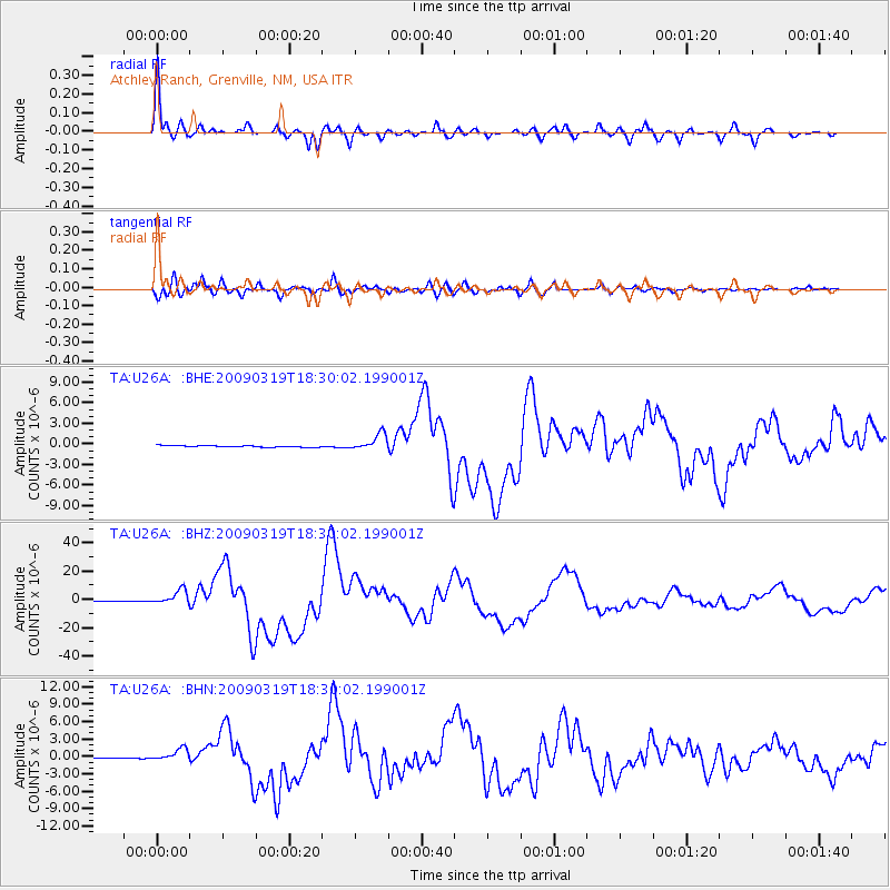
Signal To Noise
| Channel | StoN | STA | LTA |
| TA:U26A: :BHZ:20090319T18:30:02.199001Z | 25.679285 | 5.175268E-6 | 2.0153475E-7 |
| TA:U26A: :BHN:20090319T18:30:02.199001Z | 11.402827 | 1.0296264E-6 | 9.029571E-8 |
| TA:U26A: :BHE:20090319T18:30:02.199001Z | 10.608809 | 1.1967348E-6 | 1.1280576E-7 |
| Arrivals |
| Ps | 6.5 SECOND |
| PpPs | 18 SECOND |
| PsPs/PpSs | 24 SECOND |


