You are here: Home > Network List > TA - USArray Transportable Network (new EarthScope stations) Stations List
> Station I23K Minto, Yukon-Koyukuk, AK, USA > Earthquake Result Viewer
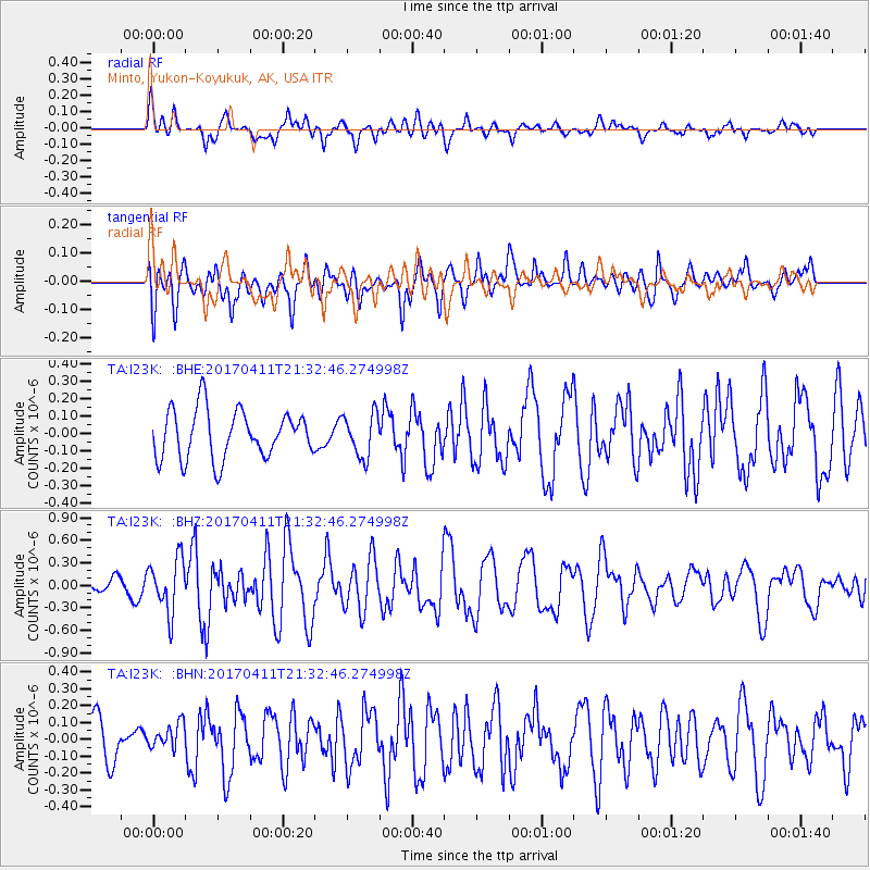
I23K Minto, Yukon-Koyukuk, AK, USA - Earthquake Result Viewer
*The percent match for this event was below the threshold and hence no stack was calculated.
| Earthquake location: |
Mindanao, Philippines |
| Earthquake latitude/longitude: |
7.7/124.8 |
| Earthquake time(UTC): |
2017/04/11 (101) 21:21:00 GMT |
| Earthquake Depth: |
6.4 km |
| Earthquake Magnitude: |
5.6 mb |
| Earthquake Catalog/Contributor: |
NEIC PDE/us |
|
| Network: |
TA USArray Transportable Network (new EarthScope stations) |
| Station: |
I23K Minto, Yukon-Koyukuk, AK, USA |
| Lat/Lon: |
65.15 N/149.36 W |
| Elevation: |
149 m |
|
| Distance: |
81.3 deg |
| Az: |
25.236 deg |
| Baz: |
269.482 deg |
| Ray Param: |
$rayparam |
*The percent match for this event was below the threshold and hence was not used in the summary stack. |
|
| Radial Match: |
56.849804 % |
| Radial Bump: |
400 |
| Transverse Match: |
56.97882 % |
| Transverse Bump: |
400 |
| SOD ConfigId: |
11737051 |
| Insert Time: |
2019-04-27 02:16:44.918 +0000 |
| GWidth: |
2.5 |
| Max Bumps: |
400 |
| Tol: |
0.001 |
|
Signal To Noise
| Channel | StoN | STA | LTA |
| TA:I23K: :BHZ:20170411T21:32:46.274998Z | 3.1675909 | 3.5443276E-7 | 1.1189348E-7 |
| TA:I23K: :BHN:20170411T21:32:46.274998Z | 0.65285546 | 7.83749E-8 | 1.2004939E-7 |
| TA:I23K: :BHE:20170411T21:32:46.274998Z | 0.86613166 | 1.1959673E-7 | 1.3808148E-7 |
| Arrivals |
| Ps | |
| PpPs | |
| PsPs/PpSs | |


