You are here: Home > Network List > TA - USArray Transportable Network (new EarthScope stations) Stations List
> Station K27K Chicken, AK, USA > Earthquake Result Viewer
K27K Chicken, AK, USA - Earthquake Result Viewer
| Earthquake location: |
Mindanao, Philippines |
| Earthquake latitude/longitude: |
7.7/124.8 |
| Earthquake time(UTC): |
2017/04/11 (101) 21:21:00 GMT |
| Earthquake Depth: |
6.4 km |
| Earthquake Magnitude: |
5.6 mb |
| Earthquake Catalog/Contributor: |
NEIC PDE/us |
|
| Network: |
TA USArray Transportable Network (new EarthScope stations) |
| Station: |
K27K Chicken, AK, USA |
| Lat/Lon: |
64.03 N/142.08 W |
| Elevation: |
389 m |
|
| Distance: |
84.5 deg |
| Az: |
26.208 deg |
| Baz: |
276.175 deg |
| Ray Param: |
0.04541528 |
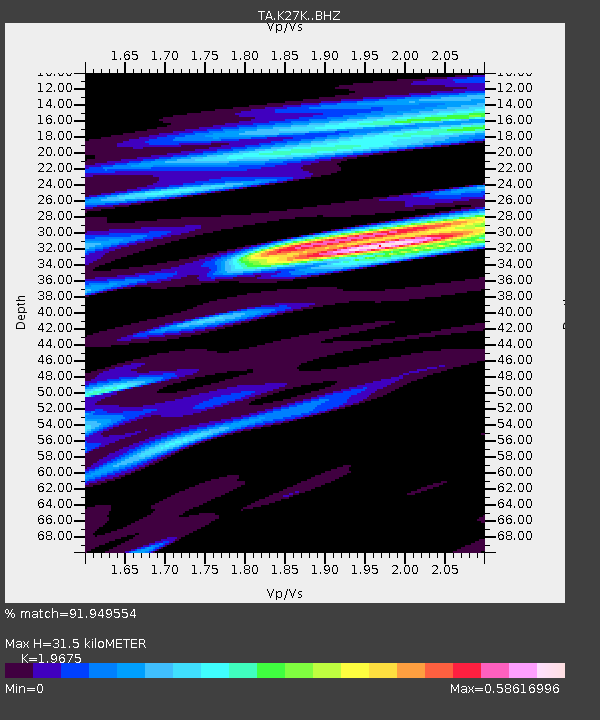
| Estimated Moho Depth: |
31.5 km |
| Estimated Crust Vp/Vs: |
1.97 |
| Assumed Crust Vp: |
6.566 km/s |
| Estimated Crust Vs: |
3.337 km/s |
| Estimated Crust Poisson's Ratio: |
0.33 |
|
| Radial Match: |
91.949554 % |
| Radial Bump: |
400 |
| Transverse Match: |
74.00564 % |
| Transverse Bump: |
400 |
| SOD ConfigId: |
11737051 |
| Insert Time: |
2019-04-27 02:16:50.813 +0000 |
| GWidth: |
2.5 |
| Max Bumps: |
400 |
| Tol: |
0.001 |
|

Signal To Noise
| Channel | StoN | STA | LTA |
| TA:K27K: :BHZ:20170411T21:33:02.749973Z | 8.731537 | 6.503514E-7 | 7.448304E-8 |
| TA:K27K: :BHN:20170411T21:33:02.749973Z | 0.9202117 | 8.534004E-8 | 9.2739576E-8 |
| TA:K27K: :BHE:20170411T21:33:02.749973Z | 3.5605636 | 2.1480211E-7 | 6.032812E-8 |
| Arrivals |
| Ps | 4.8 SECOND |
| PpPs | 14 SECOND |
| PsPs/PpSs | 19 SECOND |


