You are here: Home > Network List > TA - USArray Transportable Network (new EarthScope stations) Stations List
> Station D25K Kavik River, AK, USA > Earthquake Result Viewer
D25K Kavik River, AK, USA - Earthquake Result Viewer
*The percent match for this event was below the threshold and hence no stack was calculated.
| Earthquake location: |
Mindanao, Philippines |
| Earthquake latitude/longitude: |
7.7/124.9 |
| Earthquake time(UTC): |
2017/04/12 (102) 20:01:05 GMT |
| Earthquake Depth: |
10 km |
| Earthquake Magnitude: |
5.5 Mww |
| Earthquake Catalog/Contributor: |
NEIC PDE/us |
|
| Network: |
TA USArray Transportable Network (new EarthScope stations) |
| Station: |
D25K Kavik River, AK, USA |
| Lat/Lon: |
69.32 N/146.38 W |
| Elevation: |
770 m |
|
| Distance: |
82.4 deg |
| Az: |
20.994 deg |
| Baz: |
271.585 deg |
| Ray Param: |
$rayparam |
*The percent match for this event was below the threshold and hence was not used in the summary stack. |
|
| Radial Match: |
65.08455 % |
| Radial Bump: |
400 |
| Transverse Match: |
50.12103 % |
| Transverse Bump: |
400 |
| SOD ConfigId: |
11737051 |
| Insert Time: |
2019-04-27 02:23:07.734 +0000 |
| GWidth: |
2.5 |
| Max Bumps: |
400 |
| Tol: |
0.001 |
|
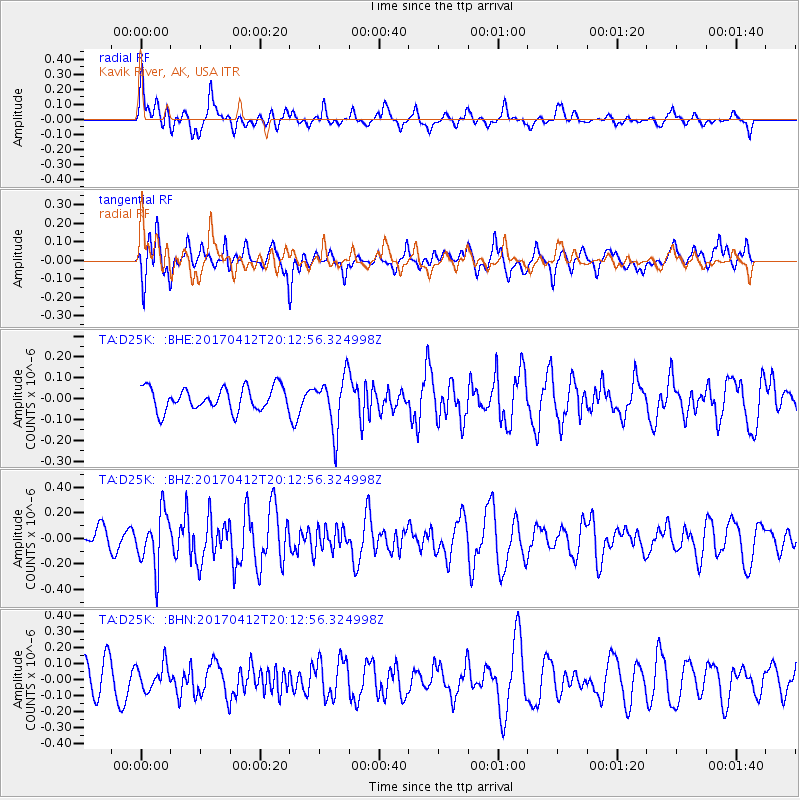
Signal To Noise
| Channel | StoN | STA | LTA |
| TA:D25K: :BHZ:20170412T20:12:56.324998Z | 2.3528252 | 2.094713E-7 | 8.902969E-8 |
| TA:D25K: :BHN:20170412T20:12:56.324998Z | 0.74304384 | 7.8228815E-8 | 1.05281565E-7 |
| TA:D25K: :BHE:20170412T20:12:56.324998Z | 2.3555915 | 1.2982987E-7 | 5.5115613E-8 |
| Arrivals |
| Ps | |
| PpPs | |
| PsPs/PpSs | |


