You are here: Home > Network List > TA - USArray Transportable Network (new EarthScope stations) Stations List
> Station J26L Joseph Creek, AK, USA > Earthquake Result Viewer
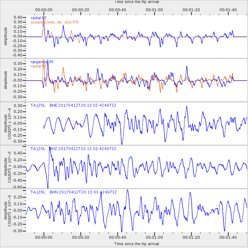
J26L Joseph Creek, AK, USA - Earthquake Result Viewer
*The percent match for this event was below the threshold and hence no stack was calculated.
| Earthquake location: |
Mindanao, Philippines |
| Earthquake latitude/longitude: |
7.7/124.9 |
| Earthquake time(UTC): |
2017/04/12 (102) 20:01:05 GMT |
| Earthquake Depth: |
10 km |
| Earthquake Magnitude: |
5.5 Mww |
| Earthquake Catalog/Contributor: |
NEIC PDE/us |
|
| Network: |
TA USArray Transportable Network (new EarthScope stations) |
| Station: |
J26L Joseph Creek, AK, USA |
| Lat/Lon: |
64.50 N/143.56 W |
| Elevation: |
1144 m |
|
| Distance: |
83.8 deg |
| Az: |
25.802 deg |
| Baz: |
274.75 deg |
| Ray Param: |
$rayparam |
*The percent match for this event was below the threshold and hence was not used in the summary stack. |
|
| Radial Match: |
66.9428 % |
| Radial Bump: |
338 |
| Transverse Match: |
54.176857 % |
| Transverse Bump: |
400 |
| SOD ConfigId: |
11737051 |
| Insert Time: |
2019-04-27 02:23:23.402 +0000 |
| GWidth: |
2.5 |
| Max Bumps: |
400 |
| Tol: |
0.001 |
|
Signal To Noise
| Channel | StoN | STA | LTA |
| TA:J26L: :BHZ:20170412T20:13:03.424973Z | 2.2671244 | 3.2924743E-7 | 1.4522689E-7 |
| TA:J26L: :BHN:20170412T20:13:03.424973Z | 0.7935804 | 6.487207E-8 | 8.174606E-8 |
| TA:J26L: :BHE:20170412T20:13:03.424973Z | 1.460779 | 1.12807754E-7 | 7.7224385E-8 |
| Arrivals |
| Ps | |
| PpPs | |
| PsPs/PpSs | |


