You are here: Home > Network List > TA - USArray Transportable Network (new EarthScope stations) Stations List
> Station P17K Kvichak River, AK, USA > Earthquake Result Viewer
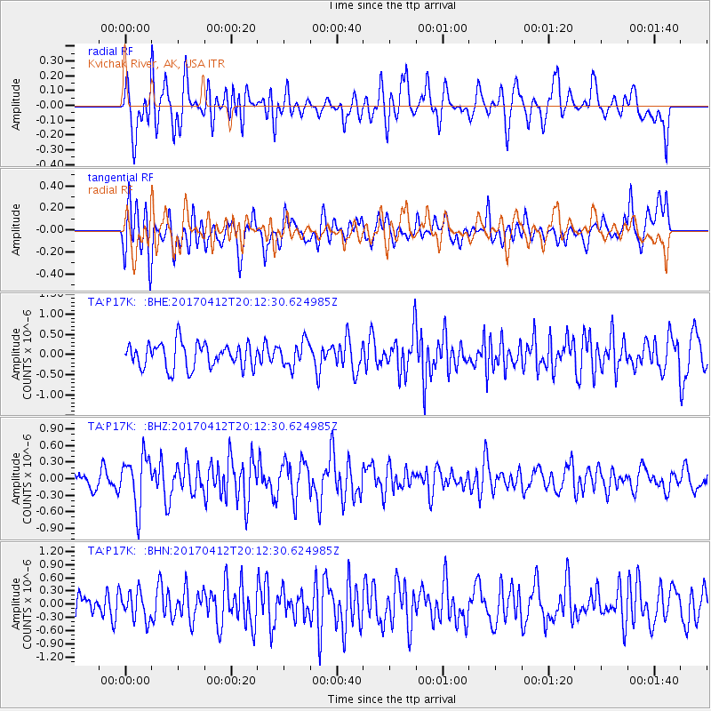
P17K Kvichak River, AK, USA - Earthquake Result Viewer
*The percent match for this event was below the threshold and hence no stack was calculated.
| Earthquake location: |
Mindanao, Philippines |
| Earthquake latitude/longitude: |
7.7/124.9 |
| Earthquake time(UTC): |
2017/04/12 (102) 20:01:05 GMT |
| Earthquake Depth: |
10 km |
| Earthquake Magnitude: |
5.5 Mww |
| Earthquake Catalog/Contributor: |
NEIC PDE/us |
|
| Network: |
TA USArray Transportable Network (new EarthScope stations) |
| Station: |
P17K Kvichak River, AK, USA |
| Lat/Lon: |
59.20 N/156.44 W |
| Elevation: |
91 m |
|
| Distance: |
77.6 deg |
| Az: |
31.11 deg |
| Baz: |
264.252 deg |
| Ray Param: |
$rayparam |
*The percent match for this event was below the threshold and hence was not used in the summary stack. |
|
| Radial Match: |
51.867878 % |
| Radial Bump: |
400 |
| Transverse Match: |
64.668526 % |
| Transverse Bump: |
400 |
| SOD ConfigId: |
11737051 |
| Insert Time: |
2019-04-27 02:23:35.711 +0000 |
| GWidth: |
2.5 |
| Max Bumps: |
400 |
| Tol: |
0.001 |
|
Signal To Noise
| Channel | StoN | STA | LTA |
| TA:P17K: :BHZ:20170412T20:12:30.624985Z | 2.3025398 | 4.6497172E-7 | 2.0193862E-7 |
| TA:P17K: :BHN:20170412T20:12:30.624985Z | 0.9671395 | 3.1870667E-7 | 3.295354E-7 |
| TA:P17K: :BHE:20170412T20:12:30.624985Z | 1.0089561 | 3.1148414E-7 | 3.0871925E-7 |
| Arrivals |
| Ps | |
| PpPs | |
| PsPs/PpSs | |


