You are here: Home > Network List > CI - Caltech Regional Seismic Network Stations List
> Station DAN Danby, California, USA > Earthquake Result Viewer
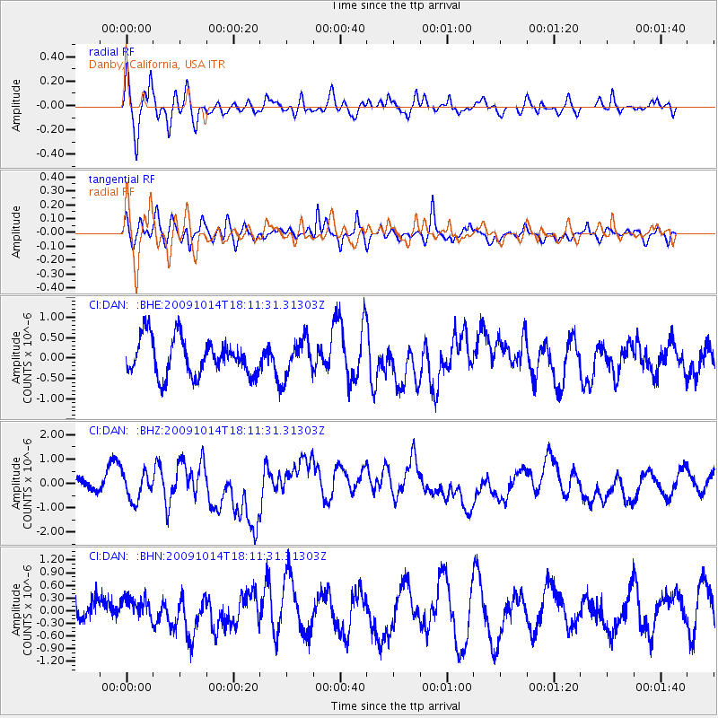
DAN Danby, California, USA - Earthquake Result Viewer
*The percent match for this event was below the threshold and hence no stack was calculated.
| Earthquake location: |
Samoa Islands Region |
| Earthquake latitude/longitude: |
-14.9/-174.8 |
| Earthquake time(UTC): |
2009/10/14 (287) 18:00:21 GMT |
| Earthquake Depth: |
10 km |
| Earthquake Magnitude: |
5.7 MB, 6.0 MS, 6.3 MW, 6.2 MW |
| Earthquake Catalog/Contributor: |
WHDF/NEIC |
|
| Network: |
CI Caltech Regional Seismic Network |
| Station: |
DAN Danby, California, USA |
| Lat/Lon: |
34.64 N/115.38 W |
| Elevation: |
398 m |
|
| Distance: |
74.9 deg |
| Az: |
47.345 deg |
| Baz: |
239.575 deg |
| Ray Param: |
$rayparam |
*The percent match for this event was below the threshold and hence was not used in the summary stack. |
|
| Radial Match: |
77.12776 % |
| Radial Bump: |
400 |
| Transverse Match: |
61.76259 % |
| Transverse Bump: |
400 |
| SOD ConfigId: |
2622 |
| Insert Time: |
2010-02-26 01:06:23.836 +0000 |
| GWidth: |
2.5 |
| Max Bumps: |
400 |
| Tol: |
0.001 |
|
Signal To Noise
| Channel | StoN | STA | LTA |
| CI:DAN: :BHZ:20091014T18:11:31.31303Z | 1.9396831 | 5.515413E-7 | 2.8434607E-7 |
| CI:DAN: :BHN:20091014T18:11:31.31303Z | 0.8773327 | 2.6963332E-7 | 3.0733304E-7 |
| CI:DAN: :BHE:20091014T18:11:31.31303Z | 0.9978074 | 4.490225E-7 | 4.5000917E-7 |
| Arrivals |
| Ps | |
| PpPs | |
| PsPs/PpSs | |


