You are here: Home > Network List > IW - Intermountain West Stations List
> Station PLID Pearl Lake, Idaho, USA > Earthquake Result Viewer
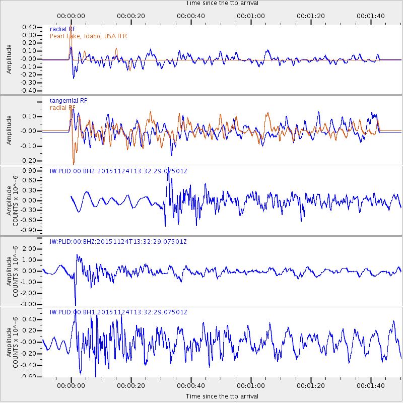
PLID Pearl Lake, Idaho, USA - Earthquake Result Viewer
*The percent match for this event was below the threshold and hence no stack was calculated.
| Earthquake location: |
Mariana Islands |
| Earthquake latitude/longitude: |
18.8/145.3 |
| Earthquake time(UTC): |
2015/11/24 (328) 13:21:36 GMT |
| Earthquake Depth: |
586 km |
| Earthquake Magnitude: |
5.9 MWB |
| Earthquake Catalog/Contributor: |
NEIC PDE/NEIC COMCAT |
|
| Network: |
IW Intermountain West |
| Station: |
PLID Pearl Lake, Idaho, USA |
| Lat/Lon: |
45.09 N/116.00 W |
| Elevation: |
2164 m |
|
| Distance: |
82.9 deg |
| Az: |
44.889 deg |
| Baz: |
289.289 deg |
| Ray Param: |
$rayparam |
*The percent match for this event was below the threshold and hence was not used in the summary stack. |
|
| Radial Match: |
66.74665 % |
| Radial Bump: |
400 |
| Transverse Match: |
66.66456 % |
| Transverse Bump: |
400 |
| SOD ConfigId: |
1259291 |
| Insert Time: |
2015-12-08 13:43:33.995 +0000 |
| GWidth: |
2.5 |
| Max Bumps: |
400 |
| Tol: |
0.001 |
|
Signal To Noise
| Channel | StoN | STA | LTA |
| IW:PLID:00:BHZ:20151124T13:32:29.07501Z | 3.1116164 | 1.0045939E-6 | 3.2285274E-7 |
| IW:PLID:00:BH1:20151124T13:32:29.07501Z | 2.3796132 | 2.748063E-7 | 1.15483594E-7 |
| IW:PLID:00:BH2:20151124T13:32:29.07501Z | 3.0932794 | 4.1922763E-7 | 1.3552854E-7 |
| Arrivals |
| Ps | |
| PpPs | |
| PsPs/PpSs | |


