You are here: Home > Network List > TA - USArray Transportable Network (new EarthScope stations) Stations List
> Station U26A Atchley Ranch, Grenville, NM, USA > Earthquake Result Viewer
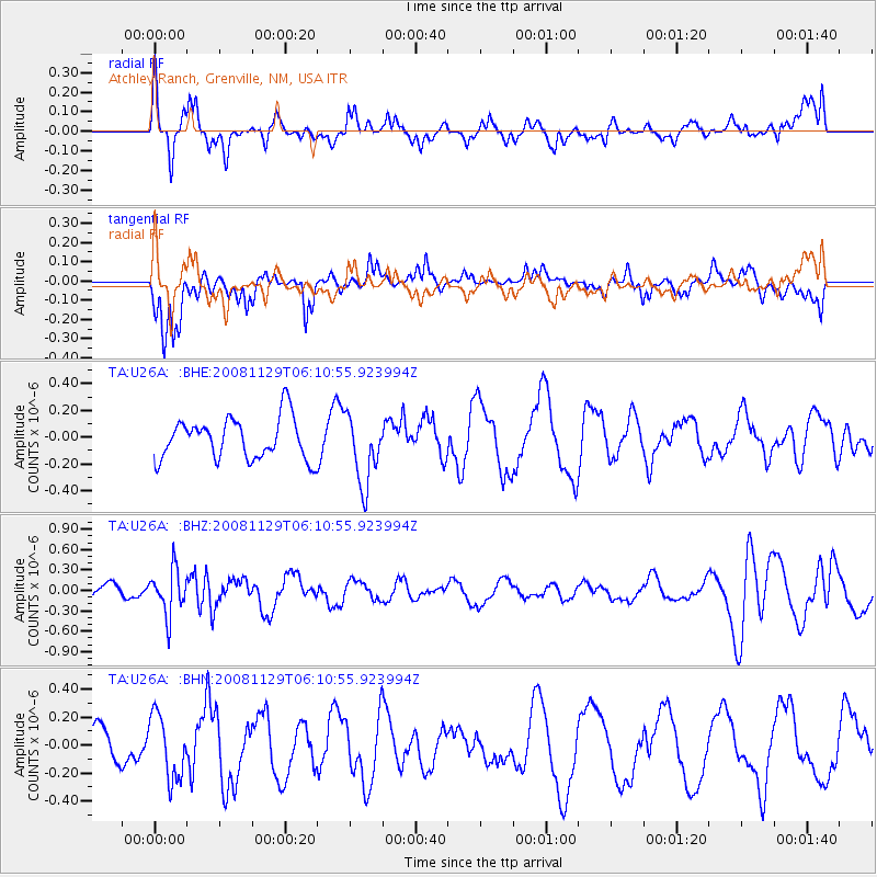
U26A Atchley Ranch, Grenville, NM, USA - Earthquake Result Viewer
*The percent match for this event was below the threshold and hence no stack was calculated.
| Earthquake location: |
Fiji Islands Region |
| Earthquake latitude/longitude: |
-18.7/-177.7 |
| Earthquake time(UTC): |
2008/11/29 (334) 05:59:16 GMT |
| Earthquake Depth: |
386 km |
| Earthquake Magnitude: |
5.7 MB, 6.0 MW, 5.9 MW |
| Earthquake Catalog/Contributor: |
WHDF/NEIC |
|
| Network: |
TA USArray Transportable Network (new EarthScope stations) |
| Station: |
U26A Atchley Ranch, Grenville, NM, USA |
| Lat/Lon: |
36.39 N/103.74 W |
| Elevation: |
1861 m |
|
| Distance: |
88.7 deg |
| Az: |
50.867 deg |
| Baz: |
245.678 deg |
| Ray Param: |
$rayparam |
*The percent match for this event was below the threshold and hence was not used in the summary stack. |
|
| Radial Match: |
66.56453 % |
| Radial Bump: |
391 |
| Transverse Match: |
58.91027 % |
| Transverse Bump: |
365 |
| SOD ConfigId: |
2658 |
| Insert Time: |
2010-03-05 22:57:33.085 +0000 |
| GWidth: |
2.5 |
| Max Bumps: |
400 |
| Tol: |
0.001 |
|
Signal To Noise
| Channel | StoN | STA | LTA |
| TA:U26A: :BHZ:20081129T06:10:55.923994Z | 1.680912 | 3.3343764E-7 | 1.983671E-7 |
| TA:U26A: :BHN:20081129T06:10:55.923994Z | 1.4904078 | 2.2776626E-7 | 1.5282144E-7 |
| TA:U26A: :BHE:20081129T06:10:55.923994Z | 1.6790017 | 2.588923E-7 | 1.541942E-7 |
| Arrivals |
| Ps | |
| PpPs | |
| PsPs/PpSs | |


