You are here: Home > Network List > TA - USArray Transportable Network (new EarthScope stations) Stations List
> Station Q17K Contact Creek, Katmai, AK, USA > Earthquake Result Viewer
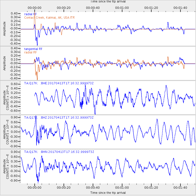
Q17K Contact Creek, Katmai, AK, USA - Earthquake Result Viewer
*The percent match for this event was below the threshold and hence no stack was calculated.
| Earthquake location: |
Fiji Islands Region |
| Earthquake latitude/longitude: |
-18.3/-178.2 |
| Earthquake time(UTC): |
2017/04/13 (103) 17:05:54 GMT |
| Earthquake Depth: |
494 km |
| Earthquake Magnitude: |
5.8 Mww |
| Earthquake Catalog/Contributor: |
NEIC PDE/us |
|
| Network: |
TA USArray Transportable Network (new EarthScope stations) |
| Station: |
Q17K Contact Creek, Katmai, AK, USA |
| Lat/Lon: |
58.26 N/155.89 W |
| Elevation: |
1165 m |
|
| Distance: |
78.5 deg |
| Az: |
11.796 deg |
| Baz: |
201.56 deg |
| Ray Param: |
$rayparam |
*The percent match for this event was below the threshold and hence was not used in the summary stack. |
|
| Radial Match: |
51.91693 % |
| Radial Bump: |
374 |
| Transverse Match: |
39.97853 % |
| Transverse Bump: |
400 |
| SOD ConfigId: |
11737051 |
| Insert Time: |
2019-04-27 02:34:56.165 +0000 |
| GWidth: |
2.5 |
| Max Bumps: |
400 |
| Tol: |
0.001 |
|
Signal To Noise
| Channel | StoN | STA | LTA |
| TA:Q17K: :BHZ:20170413T17:16:32.999973Z | 1.8756632 | 4.84239E-7 | 2.5816948E-7 |
| TA:Q17K: :BHN:20170413T17:16:32.999973Z | 1.848617 | 5.2590684E-7 | 2.8448665E-7 |
| TA:Q17K: :BHE:20170413T17:16:32.999973Z | 1.6582317 | 3.0462354E-7 | 1.8370383E-7 |
| Arrivals |
| Ps | |
| PpPs | |
| PsPs/PpSs | |


