You are here: Home > Network List > TA - USArray Transportable Network (new EarthScope stations) Stations List
> Station R32K Eaglecrest, AK, USA > Earthquake Result Viewer
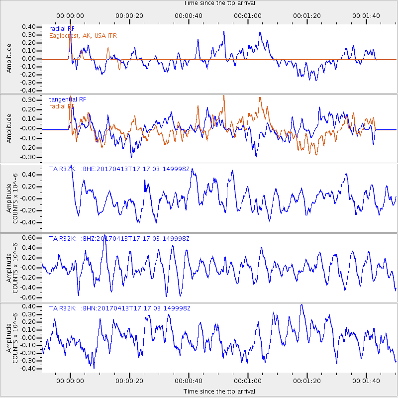
R32K Eaglecrest, AK, USA - Earthquake Result Viewer
*The percent match for this event was below the threshold and hence no stack was calculated.
| Earthquake location: |
Fiji Islands Region |
| Earthquake latitude/longitude: |
-18.3/-178.2 |
| Earthquake time(UTC): |
2017/04/13 (103) 17:05:54 GMT |
| Earthquake Depth: |
494 km |
| Earthquake Magnitude: |
5.8 Mww |
| Earthquake Catalog/Contributor: |
NEIC PDE/us |
|
| Network: |
TA USArray Transportable Network (new EarthScope stations) |
| Station: |
R32K Eaglecrest, AK, USA |
| Lat/Lon: |
58.27 N/134.52 W |
| Elevation: |
386 m |
|
| Distance: |
84.3 deg |
| Az: |
21.495 deg |
| Baz: |
221.215 deg |
| Ray Param: |
$rayparam |
*The percent match for this event was below the threshold and hence was not used in the summary stack. |
|
| Radial Match: |
44.97347 % |
| Radial Bump: |
400 |
| Transverse Match: |
38.951603 % |
| Transverse Bump: |
400 |
| SOD ConfigId: |
11737051 |
| Insert Time: |
2019-04-27 02:34:58.900 +0000 |
| GWidth: |
2.5 |
| Max Bumps: |
400 |
| Tol: |
0.001 |
|
Signal To Noise
| Channel | StoN | STA | LTA |
| TA:R32K: :BHZ:20170413T17:17:03.149998Z | 1.3068395 | 1.8229328E-7 | 1.3949172E-7 |
| TA:R32K: :BHN:20170413T17:17:03.149998Z | 0.6875659 | 1.8439306E-7 | 2.6818236E-7 |
| TA:R32K: :BHE:20170413T17:17:03.149998Z | 0.7350324 | 1.4239208E-7 | 1.9372219E-7 |
| Arrivals |
| Ps | |
| PpPs | |
| PsPs/PpSs | |


