You are here: Home > Network List > TA - USArray Transportable Network (new EarthScope stations) Stations List
> Station T26A Comanche National Grassland Park, Kim, CO, USA > Earthquake Result Viewer
T26A Comanche National Grassland Park, Kim, CO, USA - Earthquake Result Viewer
| Earthquake location: |
Southeast Of Honshu, Japan |
| Earthquake latitude/longitude: |
32.8/140.4 |
| Earthquake time(UTC): |
2009/08/12 (224) 22:48:51 GMT |
| Earthquake Depth: |
53 km |
| Earthquake Magnitude: |
6.2 MB, 6.6 MW, 6.6 MW |
| Earthquake Catalog/Contributor: |
WHDF/NEIC |
|
| Network: |
TA USArray Transportable Network (new EarthScope stations) |
| Station: |
T26A Comanche National Grassland Park, Kim, CO, USA |
| Lat/Lon: |
37.17 N/103.59 W |
| Elevation: |
1830 m |
|
| Distance: |
88.3 deg |
| Az: |
45.902 deg |
| Baz: |
310.794 deg |
| Ray Param: |
0.042596176 |
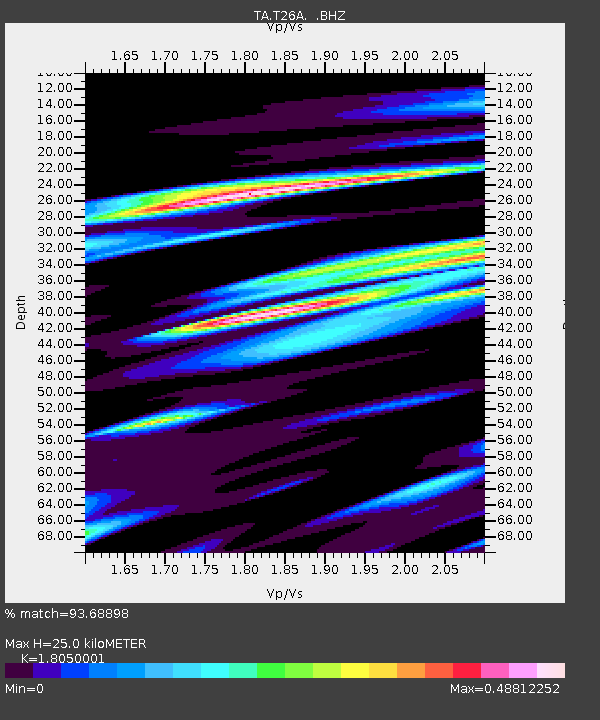
| Estimated Moho Depth: |
25.0 km |
| Estimated Crust Vp/Vs: |
1.81 |
| Assumed Crust Vp: |
6.306 km/s |
| Estimated Crust Vs: |
3.494 km/s |
| Estimated Crust Poisson's Ratio: |
0.28 |
|
| Radial Match: |
93.68898 % |
| Radial Bump: |
400 |
| Transverse Match: |
82.84667 % |
| Transverse Bump: |
400 |
| SOD ConfigId: |
2622 |
| Insert Time: |
2010-03-05 22:58:20.643 +0000 |
| GWidth: |
2.5 |
| Max Bumps: |
400 |
| Tol: |
0.001 |
|
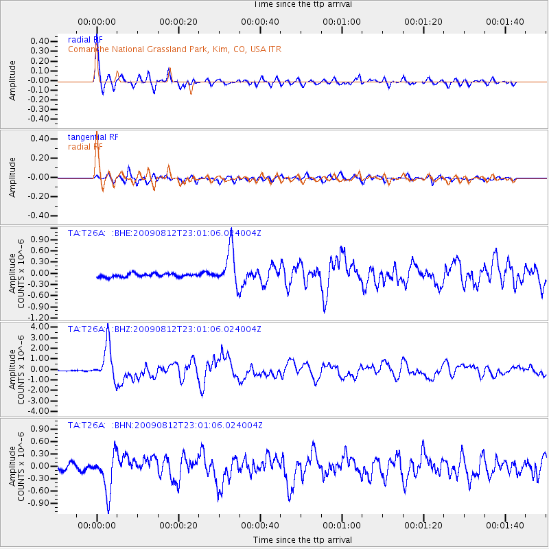
Signal To Noise
| Channel | StoN | STA | LTA |
| TA:T26A: :BHZ:20090812T23:01:06.024004Z | 51.422436 | 1.7361014E-6 | 3.3761555E-8 |
| TA:T26A: :BHN:20090812T23:01:06.024004Z | 7.702959 | 4.758497E-7 | 6.177492E-8 |
| TA:T26A: :BHE:20090812T23:01:06.024004Z | 11.199733 | 5.1646384E-7 | 4.6113943E-8 |
| Arrivals |
| Ps | 3.3 SECOND |
| PpPs | 11 SECOND |
| PsPs/PpSs | 14 SECOND |


