You are here: Home > Network List > TA - USArray Transportable Network (new EarthScope stations) Stations List
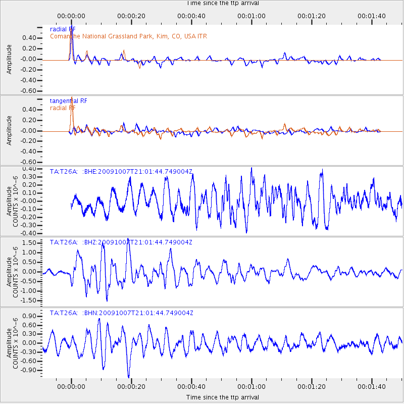
> Station T26A Comanche National Grassland Park, Kim, CO, USA > Earthquake Result Viewer
T26A Comanche National Grassland Park, Kim, CO, USA - Earthquake Result Viewer
| Earthquake location: |
East Of Severnaya Zemlya |
| Earthquake latitude/longitude: |
81.6/119.5 |
| Earthquake time(UTC): |
2009/10/07 (280) 20:52:13 GMT |
| Earthquake Depth: |
8.0 km |
| Earthquake Magnitude: |
5.7 MB, 5.1 MS, 5.8 MW, 5.8 MW |
| Earthquake Catalog/Contributor: |
WHDF/NEIC |
|
| Network: |
TA USArray Transportable Network (new EarthScope stations) |
| Station: |
T26A Comanche National Grassland Park, Kim, CO, USA |
| Lat/Lon: |
37.17 N/103.59 W |
| Elevation: |
1830 m |
|
| Distance: |
59.4 deg |
| Az: |
39.375 deg |
| Baz: |
353.271 deg |
| Ray Param: |
0.06221988 |
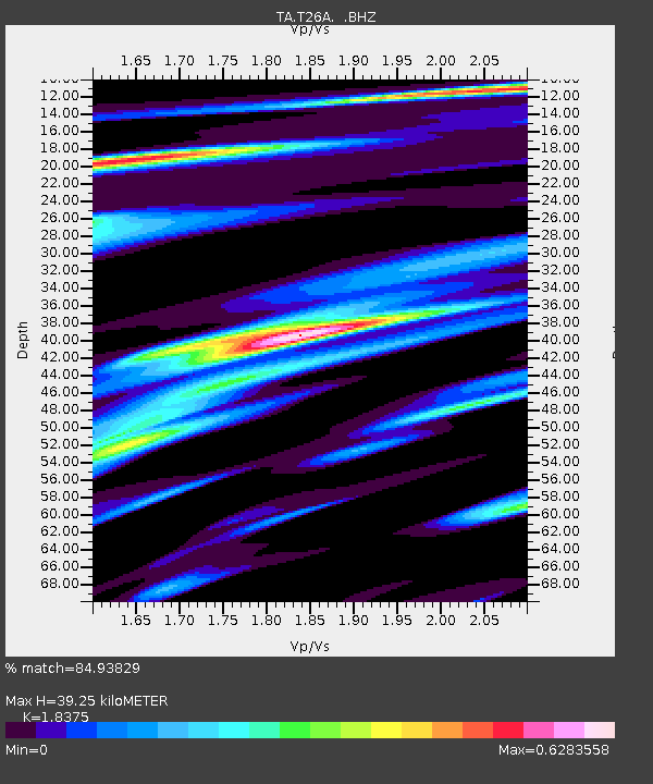
| Estimated Moho Depth: |
39.25 km |
| Estimated Crust Vp/Vs: |
1.84 |
| Assumed Crust Vp: |
6.306 km/s |
| Estimated Crust Vs: |
3.432 km/s |
| Estimated Crust Poisson's Ratio: |
0.29 |
|
| Radial Match: |
84.93829 % |
| Radial Bump: |
400 |
| Transverse Match: |
67.41774 % |
| Transverse Bump: |
400 |
| SOD ConfigId: |
2622 |
| Insert Time: |
2010-03-05 22:58:36.768 +0000 |
| GWidth: |
2.5 |
| Max Bumps: |
400 |
| Tol: |
0.001 |
|
Signal To Noise
| Channel | StoN | STA | LTA |
| TA:T26A: :BHZ:20091007T21:01:44.749004Z | 6.279584 | 6.183856E-7 | 9.847557E-8 |
| TA:T26A: :BHN:20091007T21:01:44.749004Z | 1.8362156 | 2.668817E-7 | 1.4534334E-7 |
| TA:T26A: :BHE:20091007T21:01:44.749004Z | 1.5994496 | 1.8360386E-7 | 1.14791895E-7 |
| Arrivals |
| Ps | 5.4 SECOND |
| PpPs | 17 SECOND |
| PsPs/PpSs | 22 SECOND |


