You are here: Home > Network List > TA - USArray Transportable Network (new EarthScope stations) Stations List
> Station T26A Comanche National Grassland Park, Kim, CO, USA > Earthquake Result Viewer
T26A Comanche National Grassland Park, Kim, CO, USA - Earthquake Result Viewer
| Earthquake location: |
Southern Peru |
| Earthquake latitude/longitude: |
-15.0/-70.4 |
| Earthquake time(UTC): |
2009/07/12 (193) 06:12:47 GMT |
| Earthquake Depth: |
199 km |
| Earthquake Magnitude: |
5.7 MB, 6.1 MW, 6.1 MW |
| Earthquake Catalog/Contributor: |
WHDF/NEIC |
|
| Network: |
TA USArray Transportable Network (new EarthScope stations) |
| Station: |
T26A Comanche National Grassland Park, Kim, CO, USA |
| Lat/Lon: |
37.17 N/103.59 W |
| Elevation: |
1830 m |
|
| Distance: |
60.6 deg |
| Az: |
329.911 deg |
| Baz: |
142.668 deg |
| Ray Param: |
0.06079612 |
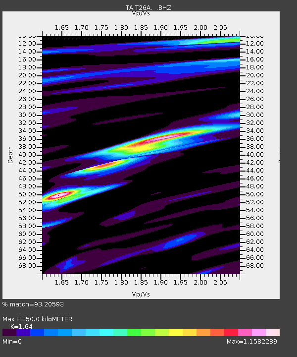
| Estimated Moho Depth: |
50.0 km |
| Estimated Crust Vp/Vs: |
1.64 |
| Assumed Crust Vp: |
6.306 km/s |
| Estimated Crust Vs: |
3.845 km/s |
| Estimated Crust Poisson's Ratio: |
0.20 |
|
| Radial Match: |
93.20593 % |
| Radial Bump: |
400 |
| Transverse Match: |
76.97694 % |
| Transverse Bump: |
400 |
| SOD ConfigId: |
2648 |
| Insert Time: |
2010-03-05 22:58:47.531 +0000 |
| GWidth: |
2.5 |
| Max Bumps: |
400 |
| Tol: |
0.001 |
|
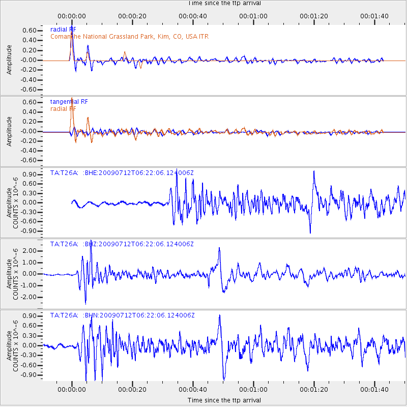
Signal To Noise
| Channel | StoN | STA | LTA |
| TA:T26A: :BHZ:20090712T06:22:06.124006Z | 14.7827 | 8.483738E-7 | 5.738964E-8 |
| TA:T26A: :BHN:20090712T06:22:06.124006Z | 8.507989 | 3.270584E-7 | 3.844133E-8 |
| TA:T26A: :BHE:20090712T06:22:06.124006Z | 6.9977665 | 3.56159E-7 | 5.0896094E-8 |
| Arrivals |
| Ps | 5.3 SECOND |
| PpPs | 20 SECOND |
| PsPs/PpSs | 25 SECOND |


