You are here: Home > Network List > TA - USArray Transportable Network (new EarthScope stations) Stations List
> Station M53A WI Miller and Sons, Farmdale, OH, USA > Earthquake Result Viewer
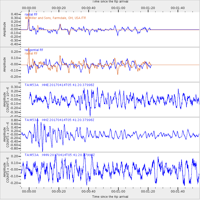
M53A WI Miller and Sons, Farmdale, OH, USA - Earthquake Result Viewer
*The percent match for this event was below the threshold and hence no stack was calculated.
| Earthquake location: |
Southern Mid-Atlantic Ridge |
| Earthquake latitude/longitude: |
-12.4/-14.8 |
| Earthquake time(UTC): |
2017/04/14 (104) 05:29:38 GMT |
| Earthquake Depth: |
10 km |
| Earthquake Magnitude: |
5.5 mb |
| Earthquake Catalog/Contributor: |
NEIC PDE/us |
|
| Network: |
TA USArray Transportable Network (new EarthScope stations) |
| Station: |
M53A WI Miller and Sons, Farmdale, OH, USA |
| Lat/Lon: |
41.44 N/80.68 W |
| Elevation: |
334 m |
|
| Distance: |
80.8 deg |
| Az: |
315.969 deg |
| Baz: |
115.421 deg |
| Ray Param: |
$rayparam |
*The percent match for this event was below the threshold and hence was not used in the summary stack. |
|
| Radial Match: |
53.9074 % |
| Radial Bump: |
375 |
| Transverse Match: |
52.650055 % |
| Transverse Bump: |
341 |
| SOD ConfigId: |
11737051 |
| Insert Time: |
2019-04-27 02:43:35.893 +0000 |
| GWidth: |
2.5 |
| Max Bumps: |
400 |
| Tol: |
0.001 |
|
Signal To Noise
| Channel | StoN | STA | LTA |
| TA:M53A: :HHZ:20170414T05:41:20.37998Z | 2.5783792 | 2.636826E-7 | 1.022668E-7 |
| TA:M53A: :HHN:20170414T05:41:20.37998Z | 1.0551893 | 5.7080204E-8 | 5.4094752E-8 |
| TA:M53A: :HHE:20170414T05:41:20.37998Z | 1.2810175 | 9.7753876E-8 | 7.6309554E-8 |
| Arrivals |
| Ps | |
| PpPs | |
| PsPs/PpSs | |


