You are here: Home > Network List > TA - USArray Transportable Network (new EarthScope stations) Stations List
> Station T26A Comanche National Grassland Park, Kim, CO, USA > Earthquake Result Viewer
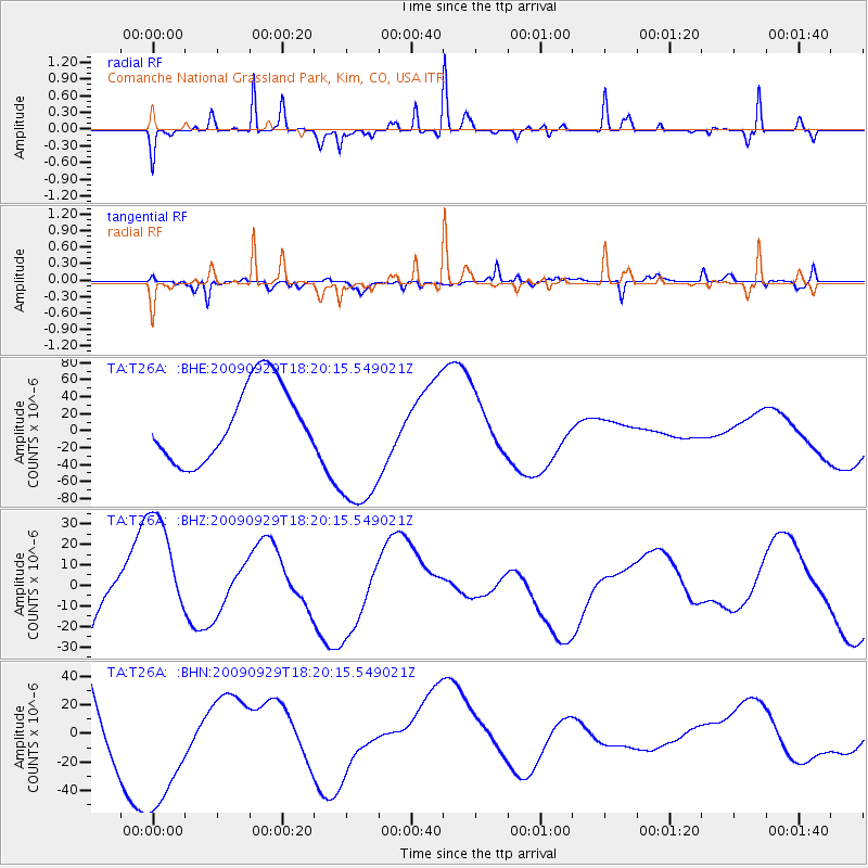
T26A Comanche National Grassland Park, Kim, CO, USA - Earthquake Result Viewer
*The percent match for this event was below the threshold and hence no stack was calculated.
| Earthquake location: |
Samoa Islands Region |
| Earthquake latitude/longitude: |
-15.6/-172.0 |
| Earthquake time(UTC): |
2009/09/29 (272) 18:08:21 GMT |
| Earthquake Depth: |
10 km |
| Earthquake Magnitude: |
5.6 MB |
| Earthquake Catalog/Contributor: |
WHDF/NEIC |
|
| Network: |
TA USArray Transportable Network (new EarthScope stations) |
| Station: |
T26A Comanche National Grassland Park, Kim, CO, USA |
| Lat/Lon: |
37.17 N/103.59 W |
| Elevation: |
1830 m |
|
| Distance: |
82.9 deg |
| Az: |
48.454 deg |
| Baz: |
244.57 deg |
| Ray Param: |
$rayparam |
*The percent match for this event was below the threshold and hence was not used in the summary stack. |
|
| Radial Match: |
60.703583 % |
| Radial Bump: |
222 |
| Transverse Match: |
57.194656 % |
| Transverse Bump: |
396 |
| SOD ConfigId: |
2622 |
| Insert Time: |
2010-03-05 22:59:20.682 +0000 |
| GWidth: |
2.5 |
| Max Bumps: |
400 |
| Tol: |
0.001 |
|
Signal To Noise
| Channel | StoN | STA | LTA |
| TA:T26A: :BHZ:20090929T18:20:15.549021Z | 1.4457815 | 2.9101519E-5 | 2.0128573E-5 |
| TA:T26A: :BHN:20090929T18:20:15.549021Z | 1.077005 | 4.9019603E-5 | 4.551474E-5 |
| TA:T26A: :BHE:20090929T18:20:15.549021Z | 1.9991324 | 8.819842E-5 | 4.411835E-5 |
| Arrivals |
| Ps | |
| PpPs | |
| PsPs/PpSs | |


