You are here: Home > Network List > CI - Caltech Regional Seismic Network Stations List
> Station FUR Furnace Creek, CA, USA > Earthquake Result Viewer
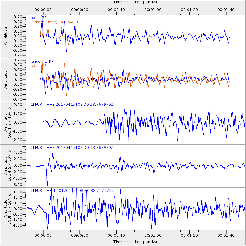
FUR Furnace Creek, CA, USA - Earthquake Result Viewer
*The percent match for this event was below the threshold and hence no stack was calculated.
| Earthquake location: |
Chile-Argentina Border Region |
| Earthquake latitude/longitude: |
-23.2/-67.7 |
| Earthquake time(UTC): |
2017/04/15 (105) 08:19:41 GMT |
| Earthquake Depth: |
135 km |
| Earthquake Magnitude: |
6.2 Mww |
| Earthquake Catalog/Contributor: |
NEIC PDE/us |
|
| Network: |
CI Caltech Regional Seismic Network |
| Station: |
FUR Furnace Creek, CA, USA |
| Lat/Lon: |
36.47 N/116.86 W |
| Elevation: |
-37.0 m |
|
| Distance: |
75.4 deg |
| Az: |
320.898 deg |
| Baz: |
133.97 deg |
| Ray Param: |
$rayparam |
*The percent match for this event was below the threshold and hence was not used in the summary stack. |
|
| Radial Match: |
75.22402 % |
| Radial Bump: |
400 |
| Transverse Match: |
78.51743 % |
| Transverse Bump: |
400 |
| SOD ConfigId: |
11737051 |
| Insert Time: |
2019-04-27 02:47:30.171 +0000 |
| GWidth: |
2.5 |
| Max Bumps: |
400 |
| Tol: |
0.001 |
|
Signal To Noise
| Channel | StoN | STA | LTA |
| CI:FUR: :HHZ:20170415T08:30:38.767979Z | 18.91448 | 1.9346041E-6 | 1.02281646E-7 |
| CI:FUR: :HHN:20170415T08:30:38.767979Z | 6.1997128 | 8.4448953E-7 | 1.362143E-7 |
| CI:FUR: :HHE:20170415T08:30:38.767979Z | 2.1520905 | 5.0552114E-7 | 2.348977E-7 |
| Arrivals |
| Ps | |
| PpPs | |
| PsPs/PpSs | |


