You are here: Home > Network List > CI - Caltech Regional Seismic Network Stations List
> Station MPP McPhearson Peak > Earthquake Result Viewer
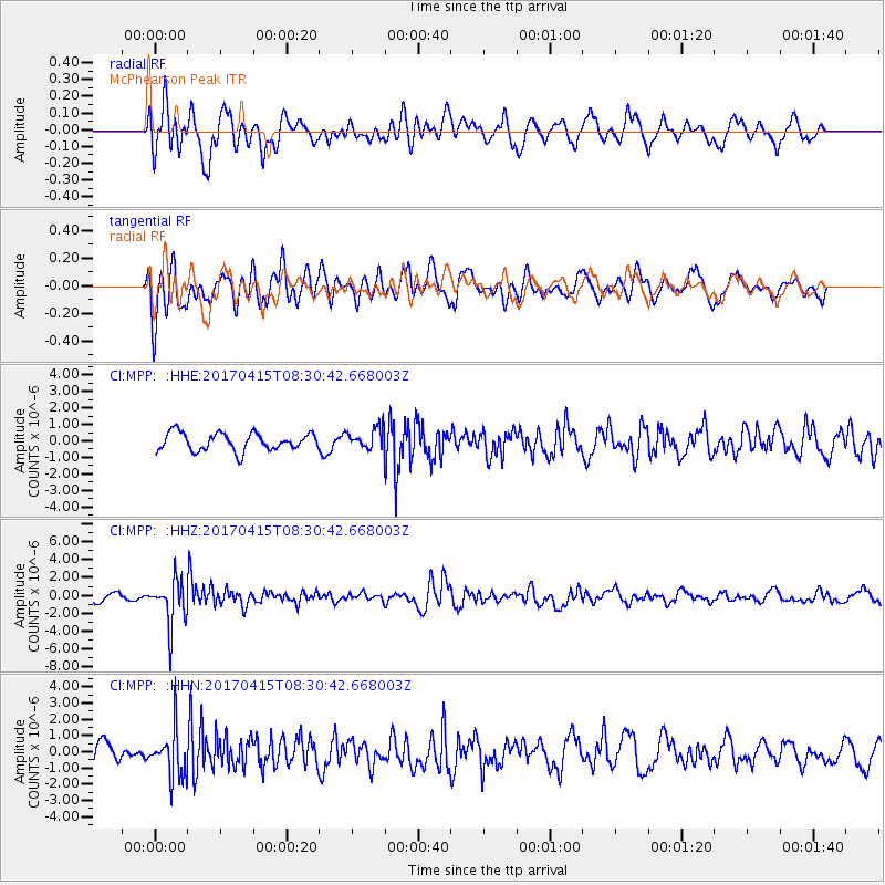
MPP McPhearson Peak - Earthquake Result Viewer
*The percent match for this event was below the threshold and hence no stack was calculated.
| Earthquake location: |
Chile-Argentina Border Region |
| Earthquake latitude/longitude: |
-23.2/-67.7 |
| Earthquake time(UTC): |
2017/04/15 (105) 08:19:41 GMT |
| Earthquake Depth: |
135 km |
| Earthquake Magnitude: |
6.2 Mww |
| Earthquake Catalog/Contributor: |
NEIC PDE/us |
|
| Network: |
CI Caltech Regional Seismic Network |
| Station: |
MPP McPhearson Peak |
| Lat/Lon: |
34.89 N/119.81 W |
| Elevation: |
1739 m |
|
| Distance: |
76.1 deg |
| Az: |
318.022 deg |
| Baz: |
131.548 deg |
| Ray Param: |
$rayparam |
*The percent match for this event was below the threshold and hence was not used in the summary stack. |
|
| Radial Match: |
57.441105 % |
| Radial Bump: |
400 |
| Transverse Match: |
60.50591 % |
| Transverse Bump: |
400 |
| SOD ConfigId: |
11737051 |
| Insert Time: |
2019-04-27 02:47:42.514 +0000 |
| GWidth: |
2.5 |
| Max Bumps: |
400 |
| Tol: |
0.001 |
|
Signal To Noise
| Channel | StoN | STA | LTA |
| CI:MPP: :HHZ:20170415T08:30:42.668003Z | 7.373896 | 2.5759523E-6 | 3.4933396E-7 |
| CI:MPP: :HHN:20170415T08:30:42.668003Z | 2.1025527 | 1.4857582E-6 | 7.0664487E-7 |
| CI:MPP: :HHE:20170415T08:30:42.668003Z | 1.6341361 | 8.968973E-7 | 5.4885106E-7 |
| Arrivals |
| Ps | |
| PpPs | |
| PsPs/PpSs | |


