You are here: Home > Network List > TA - USArray Transportable Network (new EarthScope stations) Stations List
> Station V28A Channing, TX, USA > Earthquake Result Viewer
V28A Channing, TX, USA - Earthquake Result Viewer
| Earthquake location: |
Off Coast Of Ecuador |
| Earthquake latitude/longitude: |
1.4/-85.2 |
| Earthquake time(UTC): |
2009/05/10 (130) 01:16:06 GMT |
| Earthquake Depth: |
6.0 km |
| Earthquake Magnitude: |
5.5 MB, 5.7 MS, 6.1 MW, 6.1 MW |
| Earthquake Catalog/Contributor: |
WHDF/NEIC |
|
| Network: |
TA USArray Transportable Network (new EarthScope stations) |
| Station: |
V28A Channing, TX, USA |
| Lat/Lon: |
35.75 N/102.22 W |
| Elevation: |
1163 m |
|
| Distance: |
37.7 deg |
| Az: |
337.025 deg |
| Baz: |
151.333 deg |
| Ray Param: |
0.076013155 |
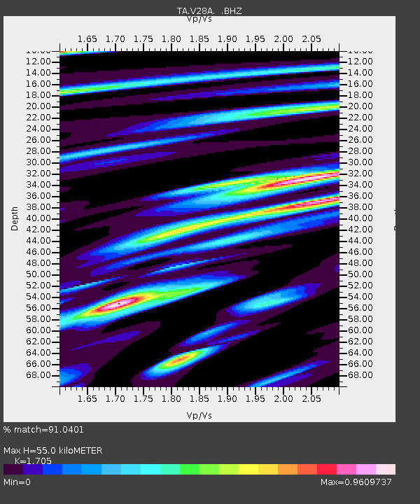
| Estimated Moho Depth: |
55.0 km |
| Estimated Crust Vp/Vs: |
1.71 |
| Assumed Crust Vp: |
6.242 km/s |
| Estimated Crust Vs: |
3.661 km/s |
| Estimated Crust Poisson's Ratio: |
0.24 |
|
| Radial Match: |
91.0401 % |
| Radial Bump: |
345 |
| Transverse Match: |
84.420105 % |
| Transverse Bump: |
397 |
| SOD ConfigId: |
2760 |
| Insert Time: |
2010-03-05 22:59:58.145 +0000 |
| GWidth: |
2.5 |
| Max Bumps: |
400 |
| Tol: |
0.001 |
|

Signal To Noise
| Channel | StoN | STA | LTA |
| TA:V28A: :BHZ:20090510T01:22:52.100015Z | 8.926544 | 8.896836E-7 | 9.966719E-8 |
| TA:V28A: :BHN:20090510T01:22:52.100015Z | 4.4670477 | 4.9601323E-7 | 1.11038254E-7 |
| TA:V28A: :BHE:20090510T01:22:52.100015Z | 3.1903455 | 3.5507344E-7 | 1.1129624E-7 |
| Arrivals |
| Ps | 6.7 SECOND |
| PpPs | 22 SECOND |
| PsPs/PpSs | 29 SECOND |


