You are here: Home > Network List > TA - USArray Transportable Network (new EarthScope stations) Stations List
> Station V28A Channing, TX, USA > Earthquake Result Viewer
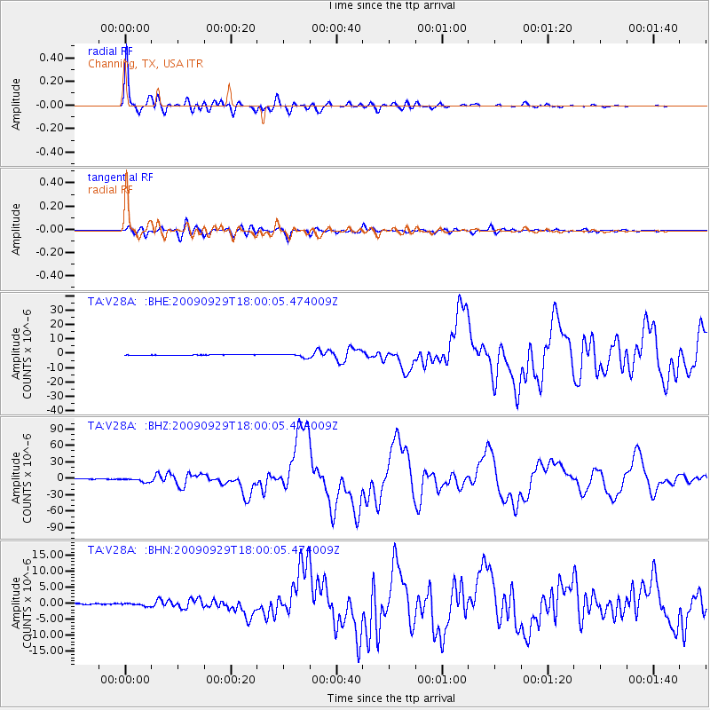
V28A Channing, TX, USA - Earthquake Result Viewer

| Earthquake location: |
Samoa Islands Region |
| Earthquake latitude/longitude: |
-15.5/-172.1 |
| Earthquake time(UTC): |
2009/09/29 (272) 17:48:10 GMT |
| Earthquake Depth: |
18 km |
| Earthquake Magnitude: |
7.1 MB, 8.1 MS, 8.1 MW, 8.0 MW |
| Earthquake Catalog/Contributor: |
WHDF/NEIC |
|
| Network: |
TA USArray Transportable Network (new EarthScope stations) |
| Station: |
V28A Channing, TX, USA |
| Lat/Lon: |
35.75 N/102.22 W |
| Elevation: |
1163 m |
|
| Distance: |
83.4 deg |
| Az: |
50.254 deg |
| Baz: |
245.693 deg |
| Ray Param: |
0.046225205 |
| Estimated Moho Depth: |
66.75 km |
| Estimated Crust Vp/Vs: |
1.76 |
| Assumed Crust Vp: |
6.242 km/s |
| Estimated Crust Vs: |
3.552 km/s |
| Estimated Crust Poisson's Ratio: |
0.26 |
|
| Radial Match: |
98.55261 % |
| Radial Bump: |
392 |
| Transverse Match: |
92.67027 % |
| Transverse Bump: |
400 |
| SOD ConfigId: |
2622 |
| Insert Time: |
2010-03-05 23:00:10.521 +0000 |
| GWidth: |
2.5 |
| Max Bumps: |
400 |
| Tol: |
0.001 |
|
Signal To Noise
| Channel | StoN | STA | LTA |
| TA:V28A: :BHZ:20090929T18:00:05.474009Z | 16.222113 | 3.5668713E-6 | 2.1987711E-7 |
| TA:V28A: :BHN:20090929T18:00:05.474009Z | 2.4498768 | 4.0278053E-7 | 1.6440849E-7 |
| TA:V28A: :BHE:20090929T18:00:05.474009Z | 5.554914 | 1.1954215E-6 | 2.1520074E-7 |
| Arrivals |
| Ps | 8.3 SECOND |
| PpPs | 29 SECOND |
| PsPs/PpSs | 37 SECOND |


