You are here: Home > Network List > CN - Canadian National Seismograph Network Stations List
> Station TRQ Mont-Tremblant, QC, CA > Earthquake Result Viewer
TRQ Mont-Tremblant, QC, CA - Earthquake Result Viewer
| Earthquake location: |
Chile-Argentina Border Region |
| Earthquake latitude/longitude: |
-23.2/-67.7 |
| Earthquake time(UTC): |
2017/04/15 (105) 08:19:41 GMT |
| Earthquake Depth: |
135 km |
| Earthquake Magnitude: |
6.2 Mww |
| Earthquake Catalog/Contributor: |
NEIC PDE/us |
|
| Network: |
CN Canadian National Seismograph Network |
| Station: |
TRQ Mont-Tremblant, QC, CA |
| Lat/Lon: |
46.22 N/74.55 W |
| Elevation: |
860 m |
|
| Distance: |
69.4 deg |
| Az: |
354.889 deg |
| Baz: |
173.222 deg |
| Ray Param: |
0.055306617 |
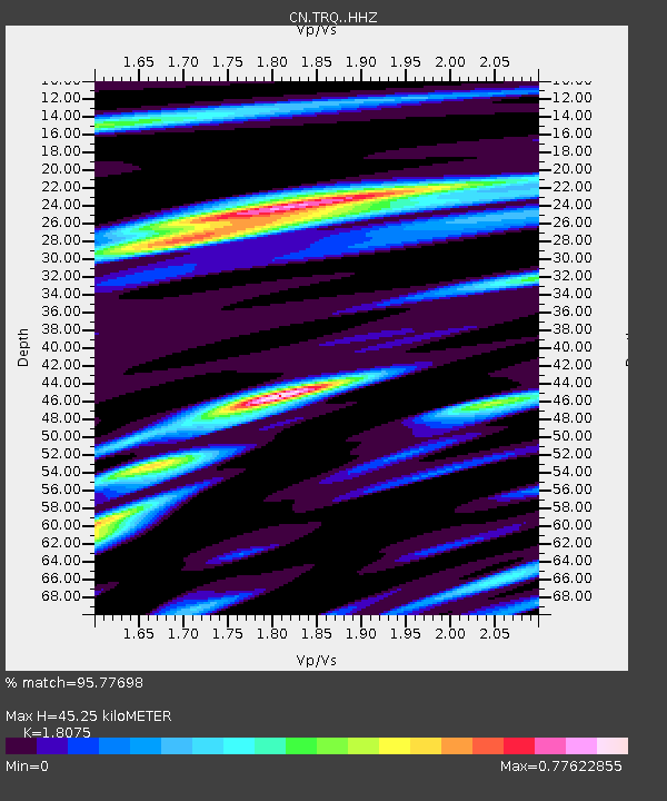
| Estimated Moho Depth: |
45.25 km |
| Estimated Crust Vp/Vs: |
1.81 |
| Assumed Crust Vp: |
6.61 km/s |
| Estimated Crust Vs: |
3.657 km/s |
| Estimated Crust Poisson's Ratio: |
0.28 |
|
| Radial Match: |
95.77698 % |
| Radial Bump: |
242 |
| Transverse Match: |
84.73115 % |
| Transverse Bump: |
400 |
| SOD ConfigId: |
11737051 |
| Insert Time: |
2019-04-27 02:49:13.784 +0000 |
| GWidth: |
2.5 |
| Max Bumps: |
400 |
| Tol: |
0.001 |
|

Signal To Noise
| Channel | StoN | STA | LTA |
| CN:TRQ: :HHZ:20170415T08:30:03.809971Z | 20.31759 | 1.3688293E-6 | 6.737164E-8 |
| CN:TRQ: :HHN:20170415T08:30:03.809971Z | 11.176326 | 7.0286245E-7 | 6.28885E-8 |
| CN:TRQ: :HHE:20170415T08:30:03.809971Z | 3.9712713 | 2.5321512E-7 | 6.376173E-8 |
| Arrivals |
| Ps | 5.7 SECOND |
| PpPs | 18 SECOND |
| PsPs/PpSs | 24 SECOND |


