You are here: Home > Network List > LD - Lamont-Doherty Cooperative Seismographic Network Stations List
> Station PANJ Princeton, NJ > Earthquake Result Viewer
PANJ Princeton, NJ - Earthquake Result Viewer
| Earthquake location: |
Chile-Argentina Border Region |
| Earthquake latitude/longitude: |
-23.2/-67.7 |
| Earthquake time(UTC): |
2017/04/15 (105) 08:19:41 GMT |
| Earthquake Depth: |
135 km |
| Earthquake Magnitude: |
6.2 Mww |
| Earthquake Catalog/Contributor: |
NEIC PDE/us |
|
| Network: |
LD Lamont-Doherty Cooperative Seismographic Network |
| Station: |
PANJ Princeton, NJ |
| Lat/Lon: |
40.38 N/74.70 W |
| Elevation: |
100 m |
|
| Distance: |
63.6 deg |
| Az: |
353.992 deg |
| Baz: |
172.76 deg |
| Ray Param: |
0.05906522 |
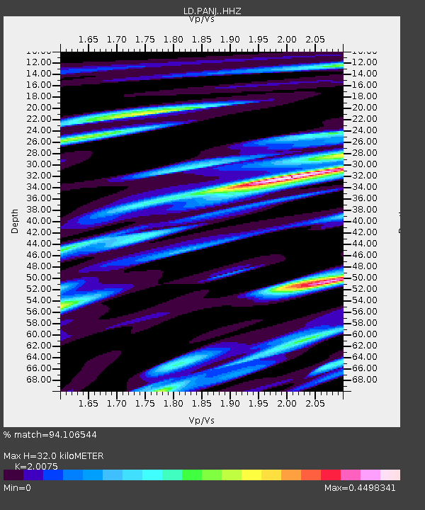
| Estimated Moho Depth: |
32.0 km |
| Estimated Crust Vp/Vs: |
2.01 |
| Assumed Crust Vp: |
6.283 km/s |
| Estimated Crust Vs: |
3.13 km/s |
| Estimated Crust Poisson's Ratio: |
0.33 |
|
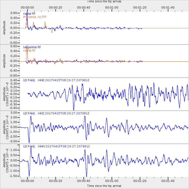
| Radial Match: |
94.106544 % |
| Radial Bump: |
240 |
| Transverse Match: |
73.72594 % |
| Transverse Bump: |
370 |
| SOD ConfigId: |
11737051 |
| Insert Time: |
2019-04-27 02:50:30.943 +0000 |
| GWidth: |
2.5 |
| Max Bumps: |
400 |
| Tol: |
0.001 |
|
Signal To Noise
| Channel | StoN | STA | LTA |
| LD:PANJ: :HHZ:20170415T08:29:27.207981Z | 12.46602 | 1.3960619E-6 | 1.1198939E-7 |
| LD:PANJ: :HHN:20170415T08:29:27.207981Z | 11.145948 | 6.395376E-7 | 5.737848E-8 |
| LD:PANJ: :HHE:20170415T08:29:27.207981Z | 3.7575736 | 1.9775104E-7 | 5.262732E-8 |
| Arrivals |
| Ps | 5.3 SECOND |
| PpPs | 15 SECOND |
| PsPs/PpSs | 20 SECOND |


