You are here: Home > Network List > LD - Lamont-Doherty Cooperative Seismographic Network Stations List
> Station TUPA Temple University, Pennsylvania > Earthquake Result Viewer
TUPA Temple University, Pennsylvania - Earthquake Result Viewer
| Earthquake location: |
Chile-Argentina Border Region |
| Earthquake latitude/longitude: |
-23.2/-67.7 |
| Earthquake time(UTC): |
2017/04/15 (105) 08:19:41 GMT |
| Earthquake Depth: |
135 km |
| Earthquake Magnitude: |
6.2 Mww |
| Earthquake Catalog/Contributor: |
NEIC PDE/us |
|
| Network: |
LD Lamont-Doherty Cooperative Seismographic Network |
| Station: |
TUPA Temple University, Pennsylvania |
| Lat/Lon: |
40.17 N/75.19 W |
| Elevation: |
112 m |
|
| Distance: |
63.5 deg |
| Az: |
353.552 deg |
| Baz: |
172.253 deg |
| Ray Param: |
0.059170708 |
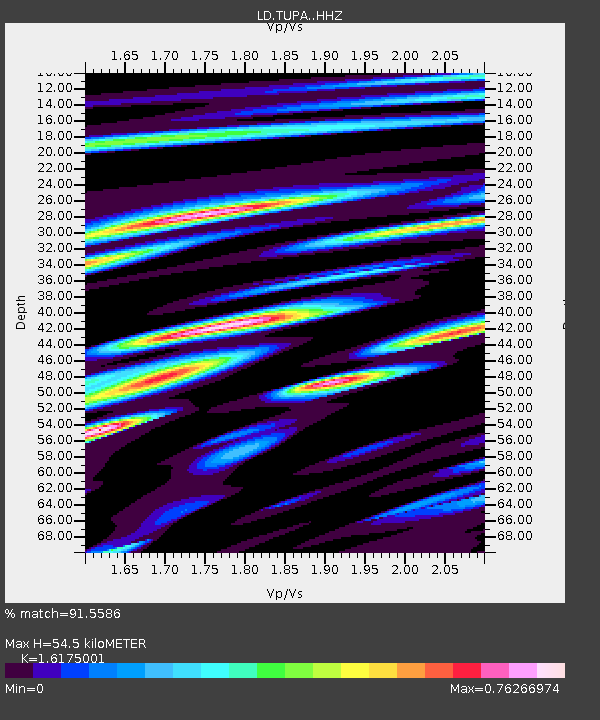
| Estimated Moho Depth: |
54.5 km |
| Estimated Crust Vp/Vs: |
1.62 |
| Assumed Crust Vp: |
6.283 km/s |
| Estimated Crust Vs: |
3.885 km/s |
| Estimated Crust Poisson's Ratio: |
0.19 |
|
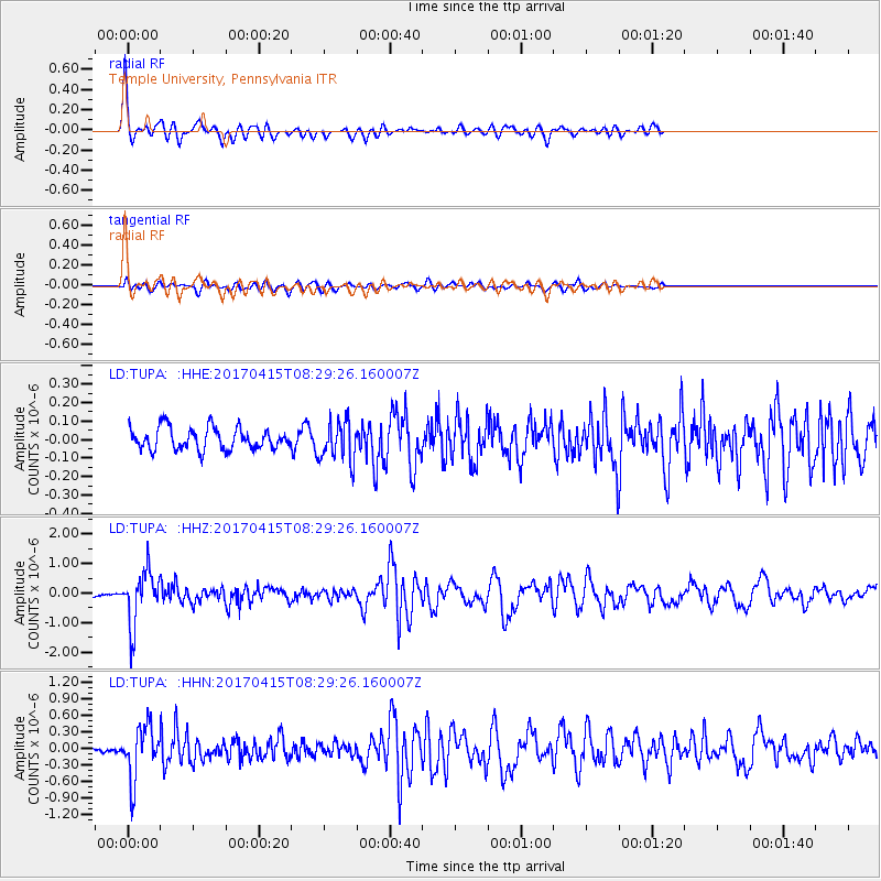
| Radial Match: |
91.5586 % |
| Radial Bump: |
343 |
| Transverse Match: |
70.0891 % |
| Transverse Bump: |
400 |
| SOD ConfigId: |
11737051 |
| Insert Time: |
2019-04-27 02:50:34.816 +0000 |
| GWidth: |
2.5 |
| Max Bumps: |
400 |
| Tol: |
0.001 |
|
Signal To Noise
| Channel | StoN | STA | LTA |
| LD:TUPA: :HHZ:20170415T08:29:26.160007Z | 12.177467 | 9.035227E-7 | 7.419627E-8 |
| LD:TUPA: :HHN:20170415T08:29:26.160007Z | 6.3459754 | 4.7979245E-7 | 7.560579E-8 |
| LD:TUPA: :HHE:20170415T08:29:26.160007Z | 1.7542005 | 1.0252685E-7 | 5.844648E-8 |
| Arrivals |
| Ps | 5.6 SECOND |
| PpPs | 22 SECOND |
| PsPs/PpSs | 27 SECOND |


