You are here: Home > Network List > LD - Lamont-Doherty Cooperative Seismographic Network Stations List
> Station TRNY Table Rock, Ramapo, NY > Earthquake Result Viewer
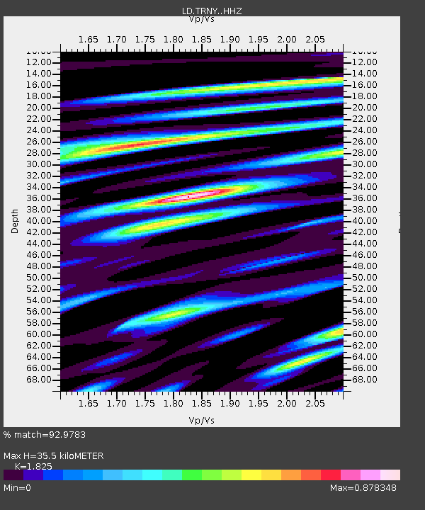
TRNY Table Rock, Ramapo, NY - Earthquake Result Viewer
| Earthquake location: |
Chile-Argentina Border Region |
| Earthquake latitude/longitude: |
-23.2/-67.7 |
| Earthquake time(UTC): |
2017/04/15 (105) 08:19:41 GMT |
| Earthquake Depth: |
135 km |
| Earthquake Magnitude: |
6.2 Mww |
| Earthquake Catalog/Contributor: |
NEIC PDE/us |
|
| Network: |
LD Lamont-Doherty Cooperative Seismographic Network |
| Station: |
TRNY Table Rock, Ramapo, NY |
| Lat/Lon: |
41.15 N/74.22 W |
| Elevation: |
270 m |
|
| Distance: |
64.3 deg |
| Az: |
354.497 deg |
| Baz: |
173.293 deg |
| Ray Param: |
0.058607243 |
| Estimated Moho Depth: |
35.5 km |
| Estimated Crust Vp/Vs: |
1.83 |
| Assumed Crust Vp: |
6.283 km/s |
| Estimated Crust Vs: |
3.443 km/s |
| Estimated Crust Poisson's Ratio: |
0.29 |
|
| Radial Match: |
92.9783 % |
| Radial Bump: |
320 |
| Transverse Match: |
80.75432 % |
| Transverse Bump: |
400 |
| SOD ConfigId: |
11737051 |
| Insert Time: |
2019-04-27 02:50:34.479 +0000 |
| GWidth: |
2.5 |
| Max Bumps: |
400 |
| Tol: |
0.001 |
|

Signal To Noise
| Channel | StoN | STA | LTA |
| LD:TRNY: :HHZ:20170415T08:29:31.894993Z | 11.959676 | 1.0191894E-6 | 8.5218815E-8 |
| LD:TRNY: :HHN:20170415T08:29:31.894993Z | 8.274789 | 5.555224E-7 | 6.713433E-8 |
| LD:TRNY: :HHE:20170415T08:29:31.894993Z | 4.3386774 | 1.8496235E-7 | 4.2631047E-8 |
| Arrivals |
| Ps | 4.8 SECOND |
| PpPs | 15 SECOND |
| PsPs/PpSs | 20 SECOND |


